That's it folks. Official rainfall in Maplewood: 0.01"

There is a line of strong thunderstorms approaching Stroudsburg, PA at this time. There are no warnings associated with this storm system. It is possible the system will diminish a bit crossing the Poconos, but we should keep an eye on the radar.
the second line of storms is now developing in western PA. They are very fragmentary at this time, but development will be dependent on conditions over the next several hours.

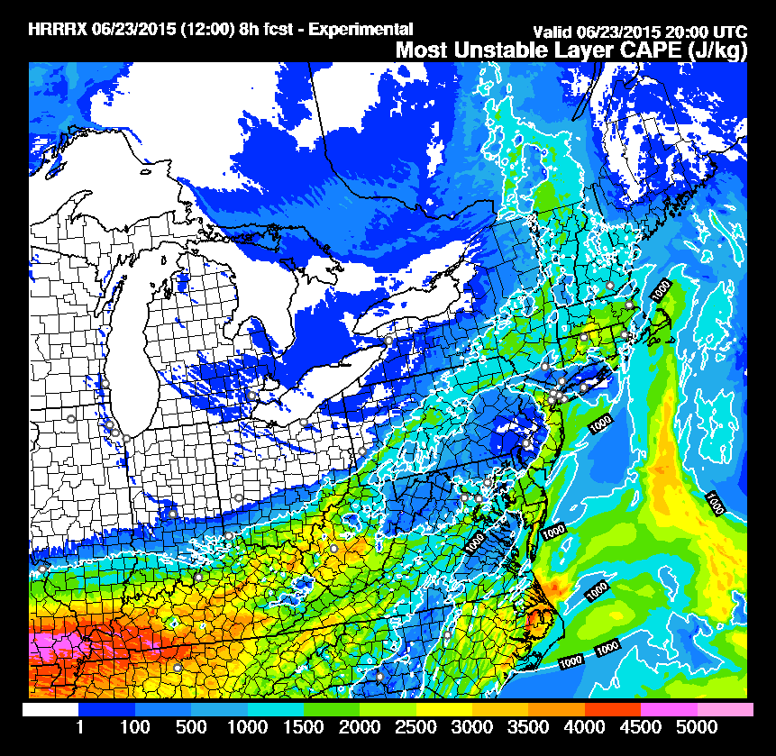
It will be interesting to see what happens. I'm not seeing CAPE values anywhere near the "scary" numbers alluded to in the other thread/tweet. The HRRR model is actually pretty mellow for both surface and intermediate CAPE from what I can see. Ran a couple of spot SkewTlogPs using nearby locations and the NAM and came up with CAPEs around 2000-2200 J/KG and cloud tops forecast up into the flight levels (30,000-40,000). Those are some pretty juicy numbers, but I've seen some 3,000+ J/DG around here pretty much every summer.
max_weisenfeld said:
There is a line of strong thunderstorms approaching Stroudsburg, PA at this time. There are no warnings associated with this storm system. It is possible the system will diminish a bit crossing the Poconos, but we should keep an eye on the radar.
the second line of storms is now developing in western PA. They are very fragmentary at this time, but development will be dependent on conditions over the next several hours.

I know. But look at central/eastern PA and you will see the higher readings that Norman is calling out. I don't think they will get this far east.
Oops, we went all jargon on them. Catch22 is looking at the aviation forecast (right?). And Norman is not a person, it is the town in Oaklahoma where the NWS storm prediction office is located.


:heehee:
max_weisenfeld said:
Oops, we went all jargon on them. Catch22 is looking at the aviation forecast (right?). And Norman is not a person, it is the town in Oaklahoma where the NWS storm prediction office is located.
Took another look and ran as a series. Looks like 20Z (4 p.m. local) we have some higher CAPEs. Still learning how the HRRR presents the graphics, but it looks like they think it washes out for a while behind the heavy storms, which is typical.
Looks like it's really juicy out toward western Kentucky and Missouri, but without the upper level lifting support?
max_weisenfeld said:
I know. But look at central/eastern PA and you will see the higher readings that Norman is calling out. I don't think they will get this far east.
Storms continue to peter out crossing the Poconos. Watches continue to be in effect through 4 pm.
Watch will expire in MAPSO at 4:00. Some severe storms are passing to our north triggering warnings in nearby zones. We should not see any severe storms in the forseable future here, although a regular old summer boomer would be welcome to cut the heat.
I don't know whether to be relieved or disappointed... Relieved, I guess, since I have to take my kid somewhere at around 7.


I was hoping not to have to water the garden tonight....... Actually, I just now got an email alert that the watch has been extended until 9:00 P.M. in our area.

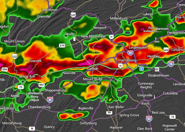
The warning kept me from going to Carlisle - looks like it was good call:

Kept me from taking kids and their friends to the pool. They are mad!

Oops.
The watch was extended until 9:00.
Two small storms just moved through the area, just missing MAPSO.
Radar shows very significant storms just south of us moving east, and north of us, also moving east. The northern storm is moving along Rt. 80. The southern, well, everywhere in NJ south of us.
Like Moses, right now the Rt. 78 corridor is splitting the waters, and at the moment it looks like this line will only rain a little on us, but things could change.
mem said:
Huge storms, Hoboken & NYC. Loud.
max_weisenfeld said:
Two small storms just moved through the area, just missing MAPSO.
Small but mighty!
The thunderstorm warning just posted starts just east of us, on the Irvington/Newark line (roughly). We are NOT included in the warning zone.

Rentals

Featured Events
-
Stephen Whitty Presents - Hometown Movie Stars: The Celebrated Actors Of CHS
May 6, 2024 at 7:00pm


Previous thread here: https://maplewood.worldwebs.com/forums/discussion/id/118264-Severe-Weather-threat-for-Tues-6-23#comment-3031484