Severe Thunderstorm Watch until 2:00 am Thursday Morning


To emphasize, this is much more of a "be aware" situation than a "cancel your plans and go shopping now" situation.


beppolina said:
Thanks, Max. How's it setting up for Wednesday?
It's going to rain, especially Wednesday night.


Can we cancel our plans (cook and clean up ourselves ) and go out to dinner?
I know that's not strictly weather related but I don't feel like washing dishes tonight.
Whatever you want -- just don't blame me if it rains tomorrow. I had nothing to do with it.
Precipitation, likely snow, will start today in the early afternoon. Snow will changeover to rain most likely in time for the evening rush. Niether snow nor rain will be very heavy; snow accumulation of less than 1/2 inch likely before changeover.
Light rain continues through the night and into Wednesday. Rain becomes heavier Wednesday and overnight, tapering off Thursday. There is no chance of temps dropping below freezing once the rain begins.

When will I learn to consult Max before I choose my shoes for the day?! I'm wearing impractical flats. Should have worn boots for the slog home.


I do have my wintry mix boots with me at work due to this thread! Thank you, Max! 
max_weisenfeld said:
Precipitation, likely snow, will start today in the early afternoon. Snow will changeover to rain most likely in time for the evening rush. Niether snow nor rain will be very heavy; snow accumulation of less than 1/2 inch likely before changeover.
Light rain continues through the night and into Wednesday. Rain becomes heavier Wednesday and overnight, tapering off Thursday. There is no chance of temps dropping below freezing once the rain begins.
So, if I'm reading this correctly, traveling south on the GSP around 5PM tonight shouldn't be a problem, weather or road condition-wise; just the usual annoying trip with slow drivers traveling in the passing lane, traffic stopping for no reason, etc.
Thanks for the update Max!
So the wind warnings have me concerned. Looks like we may need to batten down the hatches tight.

I just got an email from PSE&G about preparing for the storm and headed right over here. At least there's no ice or snow involved!
Hazardous Weather Outlook
HAZARDOUS WEATHER OUTLOOK
NATIONAL WEATHER SERVICE NEW YORK NY
402 PM EST WED FEB 24 2016
NJZ002-004-006-103>108-NYZ067>069-251900-
WESTERN PASSAIC-EASTERN PASSAIC-HUDSON-WESTERN BERGEN-EASTERN BERGEN-
WESTERN ESSEX-EASTERN ESSEX-WESTERN UNION-EASTERN UNION-ORANGE-
PUTNAM-ROCKLAND-
402 PM EST WED FEB 24 2016
THIS HAZARDOUS WEATHER OUTLOOK IS FOR NORTHEAST NEW JERSEY AND
SOUTHEAST NEW YORK.
.DAY ONE...THIS AFTERNOON AND TONIGHT.
THERE IS THE POTENTIAL FOR ISOLATED DAMAGING WIND GUSTS LATE
THIS EVENING INTO THE OVERNIGHT WITH SHOWERS AND THUNDERSTORMS
ALONG AND AHEAD OF A COLD FRONT. LOCALIZED FLOODING IN ALSO
POSSIBLE IN AREAS OF POOR DRAINAGE AND FOR THOSE FASTER RESPONDING
STREAMS AND SMALL RIVERS.
Looks like it could get nasty between 6 - midnight. Luckily this thing has not throw off a tornado since yesterday evening!
It's gusts in thunderstorms. Take the precautions you would normally take on a summer afternoon.

Max, I hate to be one of THOSE people but I have my 2 week post-op visit tomorrow morning and I will probably have difficulty getting in and out of the car and be outside more than I want. It's gonna be ok, right (Weatherwise that is?)
Much thanks
LL
aka
NCJ


Our house shook when that last thunder boom hit - and our poor dog is quaking with fear.
Rain has eased up but WIND has arrived... gusty out there right now.
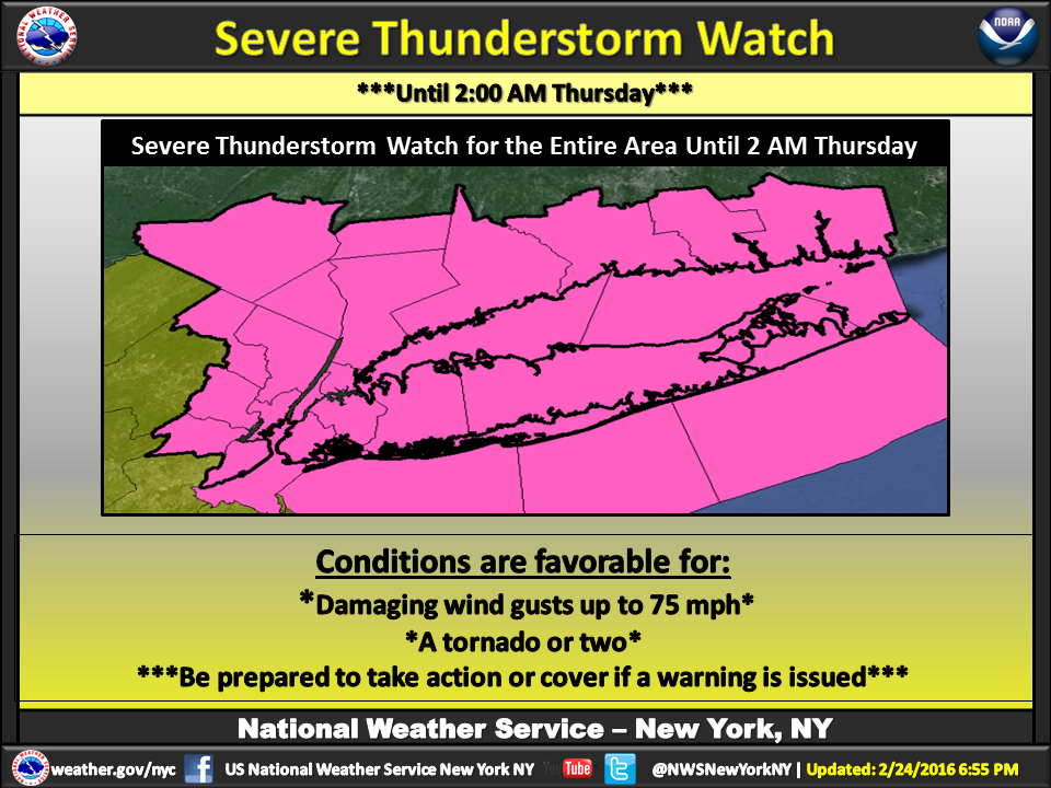
Looky what the NWS posted:
Severe Thunderstorm Watch
SEVERE THUNDERSTORM WATCH OUTLINE UPDATE FOR WS 30
NWS STORM PREDICTION CENTER NORMAN OK
740 PM EST WED FEB 24 2016
SEVERE THUNDERSTORM WATCH 30 IS IN EFFECT UNTIL 200 AM EST
FOR THE FOLLOWING LOCATIONS
NJC003-013-017-031-039-250700-
/O.NEW.KWNS.SV.A.0030.160225T0040Z-160225T0700Z/
NJ
. NEW JERSEY COUNTIES INCLUDED ARE
BERGEN ESSEX HUDSON
PASSAIC UNION
$
Special Weather Statement
SPECIAL WEATHER STATEMENT
NATIONAL WEATHER SERVICE NEW YORK NY
930 PM EST WED FEB 24 2016
NJZ002-004-006-103>108-NYZ067>070-250330-
WESTERN ESSEX-WESTERN BERGEN-HUDSON-WESTERN PASSAIC-EASTERN
UNION-EASTERN ESSEX-EASTERN BERGEN-EASTERN PASSAIC-WESTERN
UNION-ROCKLAND-PUTNAM-ORANGE-NORTHERN WESTCHESTER-
930 PM EST WED FEB 24 2016
...A LINE OF SHOWERS AND THUNDERSTORMS WILL AFFECT
ESSEX...PASSAIC...UNION...HUDSON...BERGEN...ROCKLAND...WESTERN
PUTNAM...NORTHERN WESTCHESTER AND ORANGE COUNTIES...
AT 927 PM EST...A LINE OF SHOWERS AND THUNDERSTORMS CONTINUED TO
MOVE NORTHEAST INTO WESTERN PORTIONS OF NEW JERSEY AND THE LOWER
HUDSON VALLEY OF NEW YORK. IN ANY OF THE HEAVIER RAIN...GUSTS TO 50
MPH ARE POSSIBLE. IN ADDITION...HEAVY RAIN WILL RESULT IN PONDING OF
WATER ON ROADS...AND NUISANCE FLOODING OF POOR DRAINAGE AREAS.
THE ACTIVITY WILL MOVE NORTHEAST AT 50 TO 60 MPH..
LAT...LON 4150 7448 4163 7426 4158 7413 4161 7413
4159 7395 4144 7398 4149 7393 4151 7368
4074 7405 4060 7422 4059 7446 4076 7436
4090 7434 4090 7427 4097 7428 4105 7445
4104 7450 4120 7437 4136 7469 4149 7476
TIME...MOT...LOC 0227Z 224DEG 53KT 4159 7464 4116 7450 4066 7488
$
PW
Flood Advisory
FLOOD ADVISORY
NATIONAL WEATHER SERVICE NEW YORK NY
854 PM EST WED FEB 24 2016
NJC003-013-017-031-039-250445-
/O.NEW.KOKX.FA.Y.0006.160225T0154Z-160225T0445Z/
/00000.N.ER.000000T0000Z.000000T0000Z.000000T0000Z.OO/
ESSEX NJ-UNION NJ-PASSAIC NJ-HUDSON NJ-BERGEN NJ-
854 PM EST WED FEB 24 2016
THE NATIONAL WEATHER SERVICE IN UPTON NY HAS ISSUED A
* URBAN AND SMALL STREAM FLOOD ADVISORY FOR...
ESSEX COUNTY IN NORTHEASTERN NEW JERSEY...
UNION COUNTY IN NORTHEASTERN NEW JERSEY...
PASSAIC COUNTY IN NORTHEASTERN NEW JERSEY...
HUDSON COUNTY IN NORTHEASTERN NEW JERSEY...
BERGEN COUNTY IN NORTHEASTERN NEW JERSEY...
* UNTIL 1145 PM EST
* AT 850 PM EST...DOPPLER RADAR INDICATED AN AREA OF HEAVY SHOWERS
AND THUNDERSTORMS MOVING ACROSS EASTERN PENNSYLVANIA TOWARD NEW
JERSEY. THIS ACTIVITY WILL MOVE ACROSS NORTHEAST NEW JERSEY BEFORE
10 PM AND COULD PRODUCE ANY ADDITIONAL INCH OF RAIN. AS
SUCH...THIS WILL LIKELY CAUSE URBAN AND SMALL STREAM FLOODING IN
THE ADVISORY AREA.
PRECAUTIONARY/PREPAREDNESS ACTIONS...
MOST FLOOD DEATHS OCCUR IN AUTOMOBILES. NEVER DRIVE YOUR VEHICLE INTO
AREAS WHERE THE WATER COVERS THE ROADWAY. FLOOD WATERS ARE USUALLY
DEEPER THAN THEY APPEAR. JUST ONE FOOT OF FLOWING WATER IS POWERFUL
ENOUGH TO SWEEP VEHICLES OFF THE ROAD. WHEN ENCOUNTERING FLOODED
ROADS MAKE THE SMART CHOICE...TURN AROUND...DON`T DROWN!
&&
LAT...LON 4060 7446 4067 7440 4065 7445 4067 7446
4076 7436 4079 7437 4086 7432 4090 7434
4090 7428 4089 7428 4091 7427 4100 7430
4102 7443 4105 7445 4104 7450 4109 7450
4120 7437 4099 7389 4072 7404 4061 7423
$
PW
Hazardous Weather Outlook
HAZARDOUS WEATHER OUTLOOK
NATIONAL WEATHER SERVICE NEW YORK NY
755 PM EST WED FEB 24 2016
NJZ002-004-006-103>108-NYZ067>069-252345-
WESTERN PASSAIC-EASTERN PASSAIC-HUDSON-WESTERN BERGEN-EASTERN BERGEN-
WESTERN ESSEX-EASTERN ESSEX-WESTERN UNION-EASTERN UNION-ORANGE-
PUTNAM-ROCKLAND-
755 PM EST WED FEB 24 2016
...SEVERE THUNDERSTORM WATCH 30 IN EFFECT UNTIL 2 AM EST THURSDAY...
THIS HAZARDOUS WEATHER OUTLOOK IS FOR NORTHEAST NEW JERSEY AND
SOUTHEAST NEW YORK.
.DAY ONE...TONIGHT.
PLEASE LISTEN TO NOAA WEATHER RADIO OR GO TO WEATHER.GOV ON THE
INTERNET FOR MORE INFORMATION ABOUT THE FOLLOWING HAZARDS.
SEVERE THUNDERSTORM WATCH.
THERE IS THE POTENTIAL FOR DAMAGING WIND GUSTS LATE THIS EVENING
INTO THE OVERNIGHT WITH A LINE OF SHOWERS AND THUNDERSTORMS ALONG
AND AHEAD OF A COLD FRONT. LOCALIZED FLOODING IN ALSO POSSIBLE IN
AREAS OF POOR DRAINAGE AND FOR THOSE FASTER RESPONDING STREAMS AND
SMALL RIVERS.
According to NOAA the wind speed is 28 MPH so why does it sound SO LOUD and furious?

It sounded/looked like a transformer blew. This could take a while. We pulled out the emergency kit we created during Hurricane Sandy. I'm now grading by lantern light.
That was the most powerful thunder and lightning bolt I've ever experienced. The air around me literally crackled. Not surprised to hear about power outages
Featured Events
-
Stephen Whitty Presents - Hometown Movie Stars: The Celebrated Actors Of CHS
May 6, 2024 at 7:00pm


NWS is worrying about chances of snow and sleet mixing into the rain tomorrow and tomorrow night. There are two time periods when things could get slick. At the very beginning of the precipitation tomorrow afternoon we could see a little snow before things change over to all rain before the afternoon rush. Then, tomorrow evening, cold winds could cause sleet to mix with the rain for a few hours. Precip should return to all rain after midnight.
Concerns about this forecast include timing and in particular the exact location of the freeze line, which will set up east/west across New Jersey somwhere between rt 17 and rt 78.
Both events will be minimal, perhaps an inch or two of snow, and a few hundreths of an inch of sleet, and really only of concern as they are happening as the rain following will remove the hazard.