Rain.

Hazardous Weather Outlook
HAZARDOUS WEATHER OUTLOOK
NATIONAL WEATHER SERVICE NEW YORK NY
636 AM EST SUN FEB 14 2016
NJZ004-103-105-107-151145-
EASTERN PASSAIC-WESTERN BERGEN-WESTERN ESSEX-WESTERN UNION-
636 AM EST SUN FEB 14 2016
...WIND CHILL ADVISORY IN EFFECT UNTIL NOON EST TODAY...
THIS HAZARDOUS WEATHER OUTLOOK IS FOR NORTHEAST NEW JERSEY.
.DAY ONE...TODAY AND TONIGHT.
PLEASE LISTEN TO NOAA WEATHER RADIO OR GO TO WEATHER.GOV ON THE
INTERNET FOR MORE INFORMATION ABOUT THE FOLLOWING HAZARDS.
WIND CHILL ADVISORY.
.DAYS TWO THROUGH SEVEN...MONDAY THROUGH SATURDAY.
DEVELOPING LOW PRESSURE ACROSS THE SOUTHEAST WILL MOVE UP THE
COAST MONDAY NIGHT INTO TUESDAY. THIS SYSTEM WILL LIKELY PRODUCE
SNOW MONDAY AFTERNOON...TRANSITIONING TO A WINTRY MIX MONDAY
NIGHT. AT THIS TIME...THE MAIN CONCERN IS THE POTENTIAL FOR
A FEW HOURS OF FREEZING RAIN MONDAY NIGHT. A SLOW THAW OF FROZEN
GROUND COULD RESULT IN DANGEROUS ICING OF UNTREATED ROAD SURFACES
AND WALKWAYS MONDAY NIGHT. TEMPERATURES SHOULD WARM ENOUGH
BY TUESDAY MORNING TO ALLEVIATE ICING ISSUES.
THEREAFTER...MODERATE TO HEAVY RAIN IS THEN LIKELY ON
TUESDAY...WHICH COMBINED WITH ANY SNOW MELT AND INITIALLY FROZEN
GROUND COULD CAUSE FLOODING.
THERE IS STILL UNCERTAINTY WITH THE TRACK AND TIMING OF THE LOW
PRESSURE SO STAY TUNED FOR FURTHER UPDATES THROUGH THE WEEKEND.
.SPOTTER INFORMATION STATEMENT...
SPOTTER ACTIVATION MAY BE NEEDED.
&&
THIS HAZARDOUS WEATHER OUTLOOK PROVIDES A SUMMARY OF POTENTIAL
WIDESPREAD HAZARDOUS WEATHER EVENTS THAT MAY REACH NWS WARNING
CRITERIA. MOST LONG FUSED NWS WATCHES...WARNINGS AND ADVISORIES IN
EFFECT ARE HIGHLIGHTED.
PLEASE REFER TO THE LATEST NWS FORECASTS FOR WEATHER NOT MEETING NWS
WARNING CRITERIA.
More details to follow as the models incorporate the new data later today.
So at this time the models are still showing some serious spread, but the most likely scenario is light snow Monday by noon, becoming moderate in the afternoon towards evening. Snow would change over to freezing rain sometime in the evening and continue for several hours here (less nearer the coast). Possible 2 - 4" of snow followed by icing conditions would make travel treacherous Monday night. Some time overnight or early Tuesday changeover to all rain.
Tuesday morning commute could be severely impacted in this scenario.
On Tuesday, rain, possible heavy at times. Some urban and poor drainage flooding may be possible.
This is a developing situation, expect changes to the forecast.


I'm worried about ice build up on trees resulting in branches taking out power lines. Does it look like there will be enough for that to be a worry, or is it just icy sidewalks and roadway that will be the main concern on Tuesday morning?


My kids are in Yardley, PA at their grandparents. They are supposed to come home tomorrow afternoon. Starting to wonder if we should go get them tonight or first thing in the AM. Sigh.....
Winter Weather Advisory
URGENT - WINTER WEATHER MESSAGE
NATIONAL WEATHER SERVICE NEW YORK NY
345 PM EST SUN FEB 14 2016
...A WINTRY MIX FROM MONDAY AFTERNOON INTO MONDAY NIGHT...
CTZ009>012-NJZ004-006-104>108-NYZ071>075-078-080-176>179-150445-
/O.NEW.KOKX.WW.Y.0007.160215T1800Z-160216T0500Z/
SOUTHERN FAIRFIELD-SOUTHERN NEW HAVEN-SOUTHERN MIDDLESEX-
SOUTHERN NEW LONDON-EASTERN PASSAIC-HUDSON-EASTERN BERGEN-
WESTERN ESSEX-EASTERN ESSEX-WESTERN UNION-EASTERN UNION-
SOUTHERN WESTCHESTER-NEW YORK (MANHATTAN)-BRONX-
RICHMOND (STATEN ISLAND)-KINGS (BROOKLYN)-NORTHWESTERN SUFFOLK-
SOUTHWESTERN SUFFOLK-NORTHERN QUEENS-NORTHERN NASSAU-
SOUTHERN QUEENS-SOUTHERN NASSAU-
345 PM EST SUN FEB 14 2016
...WINTER WEATHER ADVISORY IN EFFECT FROM 1 PM MONDAY TO MIDNIGHT
EST MONDAY NIGHT...
THE NATIONAL WEATHER SERVICE IN UPTON HAS ISSUED A WINTER WEATHER
ADVISORY FOR SNOW AND FREEZING RAIN...WHICH IS IN EFFECT FROM 1
PM MONDAY TO MIDNIGHT EST MONDAY NIGHT.
* LOCATIONS...NEW YORK CITY...SOUTHERN COASTAL CONNECTICUT...MOST
OF NORTHEAST NEW JERSEY...AND NASSAU AND WESTERN SUFFOLK
COUNTIES.
* HAZARD TYPES...SNOW AND FREEZING RAIN.
* ACCUMULATIONS...SNOW ACCUMULATION OF 1 TO 4 INCHES...HIGHEST
WEST OF THE GARDEN STATE PARKWAY...ALONG WITH AROUND A TRACE OF
ICE. THE EXCEPTION IS OVER WESTERN SUFFOLK COUNTY AND COASTAL
SOUTHEAST CONNECTICUT WHERE UP TO 1 INCH OF SNOW IS EXPECTED.
* TIMING...SNOW DEVELOPS LATE MONDAY MORNING AND AFTERNOON...THEN
GRADUALLY MIXES WITH AND CHANGES TO FREEZING RAIN...THEN RAIN
DURING MONDAY EVENING.
* IMPACTS...ROADS...ESPECIALLY ELEVATED AND UNTREATED
SURFACES...WILL BECOME SLIPPERY...MAKING TRAVEL DIFFICULT. THIS
WINTRY MIX WILL IMPACT THE MONDAY EVENING COMMUTE.
PRECAUTIONARY/PREPAREDNESS ACTIONS...
A WINTER WEATHER ADVISORY MEANS THAT PERIODS OF SNOW...SLEET...OR
FREEZING RAIN WILL CAUSE TRAVEL DIFFICULTIES. BE PREPARED FOR
SLIPPERY ROADS AND LIMITED VISIBILITIES...AND USE CAUTION WHILE
DRIVING.
Just waiting for the update from the NWS service. Any moment now...

Based on the latest model runs, there are revisions to the forecast in terms of timing but overall confidence is improving in the general outline.
Right now, the NWS predicts the models seem to indicate the snow starting midday Monday, with accumulations up to 4" possible for our area and points west in Jersey. This is more snow than was previously expected.
Starting Monday afternoon (earlier than previously thought) snow will likely change over to freezing rain. With the ground frozen and the ocean now at or below freezing, expect ice to form on any exposed surfaces. Expect a glaze of ice that will hang around even after the full changeover to rain due to frozen ground, and there will be frozen snow as the rain soaks in and freezes.
Changeover to full rain should happen Monday evening, most likely before midnight. Rain, heavy at times, overnight and into the morning rush, could cause minor urban flooding. After a period of rain, the ice will melt, and should not, in this timing scenario, be an issue for the morning rush.
Here's the official NWS forecast -- they still think the changeover will happen Monday night rather than evening.
Washington's Birthday
Snow likely, mainly after 2pm. Cloudy, with a high near 32. Wind chill
values between 5 and 15. Calm wind becoming south around 5 mph in the
afternoon. Chance of precipitation is 70%. New snow accumulation of 1
to 2 inches possible.
Monday Night
Snow and freezing rain before midnight, then rain and snow between midnight
and 1am, then rain after 1am. Temperature rising to around 37 by 5am.
East wind 5 to 7 mph. Chance of precipitation is 80%. Little or no ice
accumulation expected. New snow accumulation of around an inch
possible.
Tuesday
Rain. The rain could be heavy at times. High near 53. Southeast wind 7 to 13
mph becoming southwest in the afternoon. Chance of precipitation is
80%. New precipitation amounts between three quarters and one inch
possible.
Tuesday Night
Rain likely, mainly before 7pm. Mostly cloudy, with a low around 33.
Southwest wind 8 to 18 mph. Chance of precipitation is 60%. New
precipitation amounts between a tenth and quarter of an inch possible.
dang, I had just decided that driving from Portland, Maine to Amherst to Maplewood starting at noon and ending at 8 pm would work, and now I see the forecast has changed. Dang.

my dad and I have come up with a term for our weird weather: Bi-polar vortex!


Have to drive up from Philly area tomorrow. Hope to leave by 11 or 12. Wonder how driving will be at that point.
drummerboy said:
Have to drive up from Philly area tomorrow. Hope to leave by 11 or 12. Wonder how driving will be at that point.
That was my point
.
how will driving be for my trip?
It is going to be difficult to forecast the exact times in this storm in advance. Precipitation will move into our area from the south. Where the rain/snow line sets up at any given moment, and how much of that rain freezes, will be more of a nowcasting exercise. I'll review in the morning, but between my forecast and the NWS you can see the sort of time spread that exists in the various projections.
I think I have convinced the boss to stay overnight in Amherst so we don't have to deal with the weather at the end of the trip at night. Thanks for helping me figure it out, max!

I'm worried that, since schools are off, roads won't be cleaned as diligently. There are those of us who have to work tomorrow.
max_weisenfeld said:
It is going to be difficult to forecast the exact times in this storm in advance. Precipitation will move into our area from the south. Where the rain/snow line sets up at any given moment, and how much of that rain freezes, will be more of a nowcasting exercise. I'll review in the morning, but between my forecast and the NWS you can see the sort of time spread that exists in the various projections.
Updated forecast:
Forecast is still on track with a better understanding of timing. Snow will overspread the area from south to north today, reaching MAPSO in the early afternoon. This is likely to be proceeded by a period of virga where the radar will show it to be snowing, but the very dry air in place will prevent snow from reaching the ground.
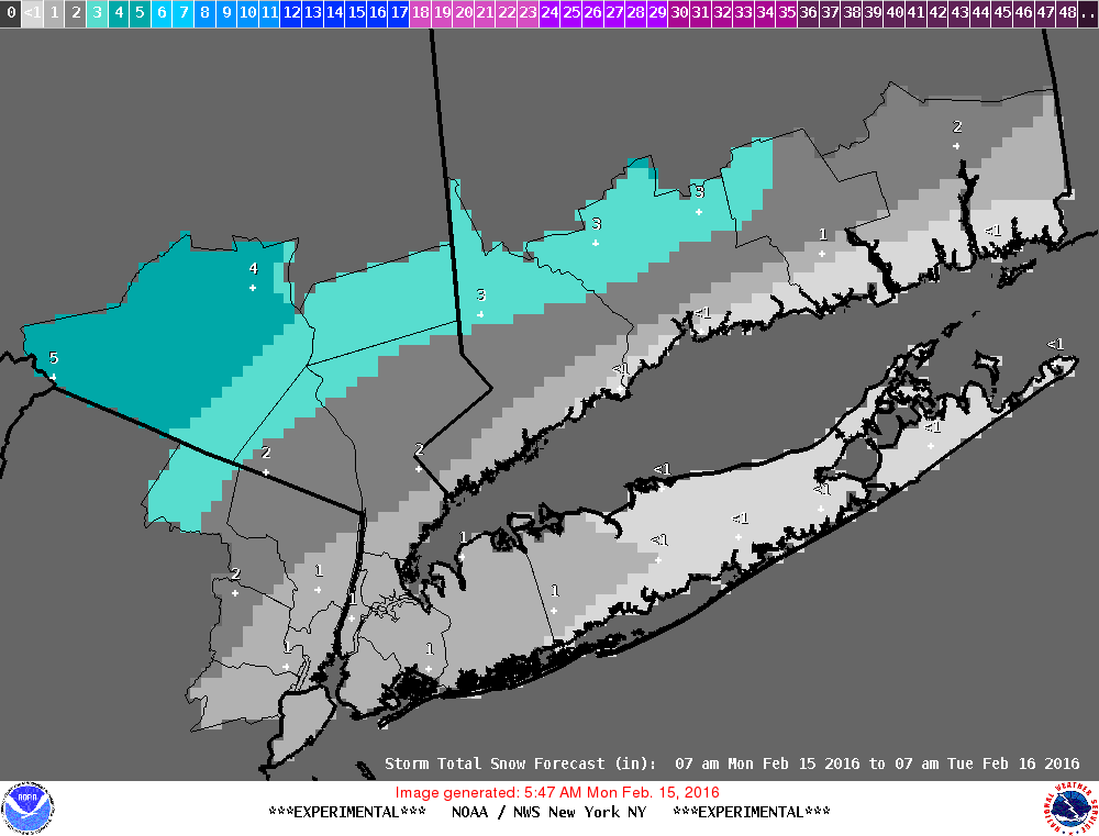
Snow will continue through this evening, totalling 2-4".
Temperatures will be rising through the afternoon, but the ground will remain very cold. Even after snow changes to rain, the cold ground will cause freezing conditions to continue. Temps will continue to rise overnight.
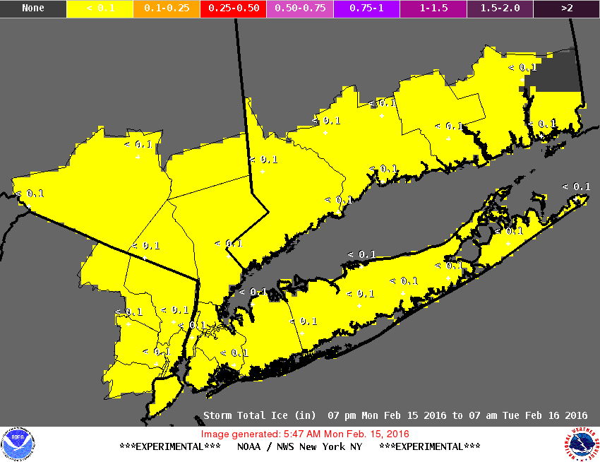
Snow changes to freezing rain overnight. Accumulation from a glaze to several hundredths of an inch are likely. Changeover to all rain will happen after midnight, and may not occur until early morning, impacting the Tuesday morning rush hour.
Moderate to heavy rain will persist all day and into the evening Tuesday.
Slight change to the advisory; NWS only expecting an inch of snow before changeover. While that looks right for the city, I think it underrepresents what we will see out here.
Winter Weather Advisory
URGENT - WINTER WEATHER MESSAGE
NATIONAL WEATHER SERVICE NEW YORK NY
310 AM EST MON FEB 15 2016
...WINTRY WEATHER THIS AFTERNOON THROUGH TONIGHT...
NJZ006-105>108-NYZ072>075-078-080-176>179-151700-
/O.CON.KOKX.WW.Y.0007.160215T1800Z-160216T0500Z/
HUDSON-WESTERN ESSEX-EASTERN ESSEX-WESTERN UNION-EASTERN UNION-
NEW YORK (MANHATTAN)-BRONX-RICHMOND (STATEN ISLAND)-
KINGS (BROOKLYN)-NORTHWESTERN SUFFOLK-SOUTHWESTERN SUFFOLK-
NORTHERN QUEENS-NORTHERN NASSAU-SOUTHERN QUEENS-SOUTHERN NASSAU-
310 AM EST MON FEB 15 2016
...WINTER WEATHER ADVISORY REMAINS IN EFFECT FROM 1 PM THIS
AFTERNOON TO MIDNIGHT EST TONIGHT...
* LOCATIONS...NEW YORK CITY...SOUTHERN COASTAL CONNECTICUT...
MOST OF NORTHEAST NEW JERSEY...AND NASSAU...SOUTHERN
WESTCHESTER AND WESTERN SUFFOLK COUNTIES.
* HAZARD TYPES...SNOW AND FREEZING RAIN.
* ACCUMULATIONS...SNOW ACCUMULATION OF UP TO 1 INCH...ALONG WITH A
GLAZE OF ICE.
* TIMING...SNOW DEVELOPS LATE THIS MORNING...THEN BRIEFLY MIXES
WITH AND CHANGES TO FREEZING RAIN...BEFORE CHANGING TO PLAIN
RAIN LATER TONIGHT.
* IMPACTS...A SLOW THAW OF FROZEN GROUND WILL LIKELY RESULT IN
ICING OF UNTREATED ROAD SURFACES AND WALKWAYS THIS EVENING INTO
LATE TONIGHT...MAKING TRAVEL DANGEROUS. THESE CONDITIONS WILL
IMPACT THE EVENING COMMUTE.
PRECAUTIONARY/PREPAREDNESS ACTIONS...
A WINTER WEATHER ADVISORY MEANS THAT PERIODS OF SNOW...SLEET...OR
FREEZING RAIN WILL CAUSE TRAVEL DIFFICULTIES. BE PREPARED FOR
SLIPPERY ROADS AND LIMITED VISIBILITIES...AND USE CAUTION WHILE
DRIVING.
Just so I understand: the ground being so cold means there won't be icing during the day?
deborahg said:
Just so I understand: the ground being so cold means there won't be icing during the day?
The ground being so cold means that not only will there be icing but that it will continue longer than the air tempurature would indicate. Icing will start on cleared surfaces as soon as air temps rise above 30-32 degrees. It will continue mostly theough the night.
deborahg said:
Just so I understand: the ground being so cold means there won't be icing during the day?
I think it means the opposite.


Still sketchy on the details, as a big part of the energy is just coming onshore on the west coast this morning, but there is some fairly compelling indicators that we are in for heavy rain Monday and Tuesday. Monday, the precipitation may start during the day as snow, and transition overnight through freezing rain to regular rain.