November weather thread


Wed Nov 5
Wind Advisory tonight with a steady breeze in the mid 20mph range but gusts of 40+ mph possible
Today, mixed sun and clouds, high mid 60⁰s, overnight low mid 40⁰s, windy overnight with some strong gusts possible
Thursday sunny high mid 50⁰s low mid 30⁰s maybe some touches of frost
Friday starts out clear but clouds gather in the afternoon high upper 50⁰s. Overnight likely showers and perhaps a modest steady rain near morning, low around 50⁰
Saturday rain ends a bit warmer as the sun comes out high mid 60⁰s low mid 40⁰s
Sunday chance of showers high around 60⁰ low in the 30⁰s
Friday November 7th
Mix of sun and showers this weekend
Today, partly cloudy, breezy, high upper 50⁰s low lower 50⁰s. Tonight showers likely
Saturday clearing, a bit warmer (might break 60⁰) overnight low mid 40⁰s
Sunday mostly cloudy showers likely in the afternoon, high near 60⁰ overnight showers low mid 40⁰s
Monday showers ending in the morning, clearing, breezy. Monday night frost possible
Mon Nov 10th
Showers are ending/have ended this morning, although some models show a bit of shower activity this afternoon. Becoming partly cloudy and breezy, the high in the low 50⁰s happening now and the temps will fall into the mid 40⁰s later today. Tonight, frost likely with temps in the low 30⁰s
Tuesday through Friday, partly cloudy to mostly sunny, breezy, highs in the mid 50⁰s and overnight lows in the mid to low 30⁰s as a progression of weak fronts pass through
Update Tue Nov 11th
As forecast, temps will only be in the lower 40⁰s today. With winds in the 20mph range and higher gusts (30mph and perhaps a few up to 40) though, the temps will feel like 20-25⁰. Dress appropriately


With this cold weather, and and having over-enjoyed some leftover Halloween candy, I'm feeling just about ready to hibernate for the winter.

sprout said:
With this cold weather, and and having over-enjoyed some leftover Halloween candy, I'm feeling just about ready to hibernate for the winter.
This is a discouraging, if perhaps not surprising, sentiment to hear from someone named sprout.

DaveSchmidt said:
This is a discouraging, if perhaps not surprising, sentiment to hear from someone named sprout.
looking forward to hear from him in the spring…
I am hoping to be nicely refreshed (and possibly more recognizable as 'her') once the weather warms back up! 
My Grumpy Cat avatar (also a female) does give off grumpy-old-man vibes... and with my grumblings about the winter weather, being covered by 20 layers of clothing, and becoming an old-timer posting semi-anonymously on the internet... well, it's all very understandable.
Fri Nov 14th
Today, mostly sunny high 50⁰ breezy this afternoon, chance of frost tonight
Saturday sunny, more clouds towards evening, high in the low 50⁰s, then rain likely overnight low mid 40⁰s
Sunday clearing mid 50s, breezy with chance of gusts in the mid 30mph range, low mid 30⁰s
Monday and Tuesday partly cloudy to mostly sunny, breezy again on monday, high low 50⁰s, overnight chance of frost
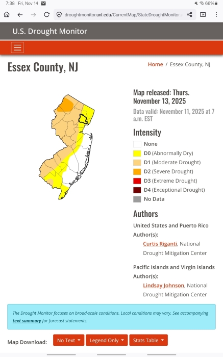
Just a reminder Essex county is still abnormally dry and much of new jersey is in stage 1 drought, be mindful of water use and watch those lovely fall fire pits carefully
Monday Nov 17th
Windy again today, though not quite so windy as yesterday, then a couple of days of fair fall weather
Today, mostly clear mid 40⁰s low overnight near freezing, wind 20-25mph steady gusts mid 30s mph
Tuesday - Thurs more clouds, highs upper 40⁰s lows upper 30⁰s chance of a shower Tuesday night
Unsettled weather towards the end of the week as the models show a complex system and varying solutions, so let's just say chance of rain as early as Thursday night and leave the details for a future post when we know more
Wed Nov 19th
Rain this morning, then chance of rain Friday but the storm signals in the models have abated so not expecting any rain to be heavy
Today, rain ending late morning. High mid 40⁰s overnight low mid 30⁰s
Thursday partly cloudy, a bit warmer with highs near 50⁰ and low in the lower 40⁰s
Friday cloudy, might see rain in the late afternoon, then chance of rain overnight, high mid 50⁰s low near 40⁰
Chance of rain early Saturday then clouds, low 50⁰s during the day and
upper 30⁰s overnight
Sunday mostly clear, lower 50⁰s

Friday Nov 21
Today, partly cloudy becoming overcast in the afternoon, rain likely overnight high in the lower 50⁰s low lower 40⁰s
Weekend and Monday mostly sunny during the day, more clouds at night, highs in the lower 50⁰s lows in the low to mid 30⁰s
Tuesday rain likely, probably late in the day or overnight, high mid 50⁰s low upper 40⁰s
Wednesday chance rain
Thanksgiving as of now looks dry
Monday Nov 24th
Today, mostly clear, mid 50⁰s, overnight low mid 30⁰s
Tuesday clouds gather, then chance of rain in the afternoon becomes rain likely in the evening, might have some periods of moderate to heavy rain overnight but the risk of flooding is low except where leave clog the storm drains. High mid 50⁰s
Wednesday rain likely ends mid morning, relatively warm with high in the low to mid 60⁰s but colder overnight with low into the upper 30⁰s
Thanksgiving partly cloudy and dry. Could get quite breezy though, fingers crossed for the balloons, dress warm if you are going to the parade, high mid 40⁰s but likely wind chill in the 30⁰s. Temp drops into the 30⁰s and perhaps below freezing overnight
Still breezy Friday high low 40⁰s low again possibly below freezing

Sponsored Business


Promote your business here - Businesses get highlighted throughout the site and you can add a deal.


Monday November 3rd
Today, chance of showers, most likely in the afternoon and early evening but not more than chance at any point. Breezy overnight, clearing, high mid 50⁰s and overnight low mid 40⁰s
Tuesday breezy and clear, high near 60⁰ low mid 40⁰s
Wed and Thursday clear to partly cloudy high mid to upper 50⁰s low mid 40⁰s
Friday partly cloudy, breezy, chance showers overnight