March weather thread


Thank you for the new weather thread. I’m starting to feel ready for some new weather.


Twenty or more robins sunning themselves in a tree in the backyard this morning.

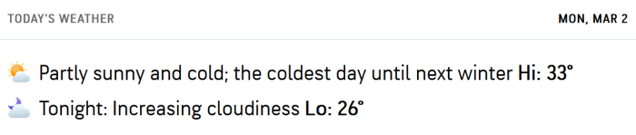
I like this message on accuweather: "The coldest day until next winter"!
jamie said:
I like this message on accuweather: "The coldest day until next winter"!
Why do they tempt fate with that kind of prognostication?


yahooyahoo said:
We are supposed to hit 70F next week!
A couple of years ago it was 85F in February and I drove down to Asbury Park to hang out, even though nothing was open. 2 days later we had snow.
We’re going to be able to witness a lunar eclipse tomorrow. Just have to get up by 6 or so.
https://www.space.com/news/live/total-lunar-eclipse-blood-moon-march-3-2026-live-updates

mrincredible said:
We’re going to be able to witness a lunar eclipse tomorrow. Just have to get up by 6 or so.
https://www.space.com/news/live/total-lunar-eclipse-blood-moon-march-3-2026-live-updates
If afraid our view will be cloud covered.

yahooyahoo said:
We are supposed to hit 70F next week!
I'm going to Costa Rica then ... I guess we should have planned that for a couple of weeks ago.
mrincredible said:
We’re going to be able to witness a lunar eclipse tomorrow. Just have to get up by 6 or so.
https://www.space.com/news/live/total-lunar-eclipse-blood-moon-march-3-2026-live-updates
I was trying to figure out a not-too-distant place to go to see that, but now the weather forecast has convinced me not to set my alarm.
This is one I took about 20 years ago. It was an October supermoon, not an eclipse .
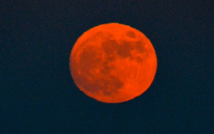
I was actually outside this morning a little before the time of the eclipse, but it was completely overcast, no moon. 😢 I saw a lunar eclipse once many years ago and would love to see it again. It is beautiful.

Blurry and grainy, unfortunately. Hand-held phone camera from my location around 2330 my time. (AEDT)


mrincredible said:
Why do they tempt fate with that kind of prognostication?
temps are supposed to rise a bit through the overnight. The possibility of one more sub-freezing day in March or even April remains. But it's also possible this morning was the coldest temp will see for several months. 

Wednesday March 4th
Sunny day, rainy day, then a hint of spring
Today, partly sunny, perhaps a bit of fog in the morning, high near 50⁰, low tonight upper 30⁰s
Thursday rain likely, light to moderate during the day, moderate overnight, high and low around 40⁰
Friday morning, light rain likely, then slight chance of light rain ending in the afternoon. High mid 40⁰s low upper 30⁰s
Saturday slight chance of light rain gives way to overcast, high near 60⁰, low upper 40⁰s
Sunday overcast, slight chance of rain, high near 60⁰ low upper 40⁰s

Friday March 6th
Overcast start to the weekend, then warmer
Today, overcast with periods of light rain possible, breezy this afternoon and tonight, high mid 40⁰s low mid 30⁰s
Saturday overcast, maybe some drizzles to start, still breezy, high mid 50⁰s (!), low upper 40⁰s overnight, perhaps a shower
Sunday perhaps a shower early, then partial clearing, high in the lowers 60⁰s (!!), low in the 40⁰s
Monday and Tuesday looking mostly clear dry, and warm with highs in tte lower 60⁰s
Monday March 9th
A fair and warm start to the week
Today and Tuesday, mostly clear and sunny, highs around 70⁰, overnight lows in the mid 40⁰s
Wednesday, still warm, high near 70⁰, but clouds move in with a chance of showers in the afternoon and showers/rain likely overnight. Low mid 50⁰s, breezy
Showers continue into Thursday, ending with possible wet snow Thursday morning, little or no accumulation. Thursday's temps drop during the day, high mid 50⁰s early, fall into the 40⁰s in the afternoon
Wed March 11th
March does the lamb/lion thing
Today starts out mostly clear, sunny, and warm with highs near 80 degrees. There's a slight chance of showers this afternoon, becoming likely showers tonight as a front moves through the area. Temperatures drop into the 60s, the wind picks up, and there's a slight chance of a rumble of thunder.
Thursday chance of showers continues through the morning, breezy with gusts up to 30mph. Temps continue to drop into the 40⁰s, the day should be warmest at dawn. Clearing overnight
Friday partly cloudy, cooler, continued breezy and gusty winds likely, high near 50⁰, low near freezing
Saturday sunny and seasonal, high near 50⁰ low just above freezing
Sunday likley more overcast, high around 50⁰ low mid 40⁰s
It sounds like we will miss the worst of the front coming through today. I read somewhere the winds could get up to 70mph.
Thursday March 12 update
Current temp this morning is likely the high for today as a cold front moves through taking temps down into the 30⁰s tonight. Rain and showers continue with a possibility of snow mixing in, accumulation unlikely
The next rain event is Sunday into Monday and appears to be all rain
Breezy conditions with steady winds in the teens and gusts in the 30mph range
Friday March 13th
Seasonal temps with rain to come after the weekend
Today starts out clear then partly cloudy, breezy this afternoon, highs in the upper 40⁰s low overnight in the upper 30⁰s
Saturday sunny and breezy, high around 50⁰ low mid 30⁰s
Sunday cloudy and breezy, high around 50⁰ low mid 40⁰s, possibly a shower overnight becomes rain likely in the early am
Monday rain likely, moderate to heavy as a line of rain comes through with some wind and possibly a thunderstorm. High mid 60⁰s, low after the front passes in the upper 30⁰s
Rain should be gone by Tuesday morning, then clearing, still breezy, high mid 40⁰s but cold overnight, low in the 20⁰s
Sunday 3/15 update
Forecast on track for a rainy and potentially stormy Monday.
A frontal system will be moving through the area tonight into and through Monday and Mon day night bringing very likely rain showers that have the potential to be heavy at times, with a possibility of thunderstorms.
TLDR:
Today clearing in the morning then sunny, high near 50
Tonight, showers and possibly a thunderstorm after midnight, low lower 40s then will start rising and could hit 50 again by sunrise Monday
Monday showers and possibly a thunderstorm or two. High in the 60s, windy.
Monday night, rain showers overnight, slight possibility of another thunderstorm, chance of a little snow mixing in with no accumulation likely, low around freezing
Tuesday clearing, breezy, high around 40
The more nerdy version:
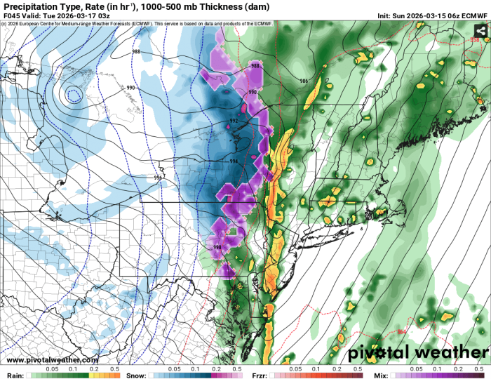
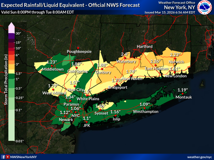
The models are in good agreement, with most showing the passage of two distinct squall lines through the area from west to east. These periods of heavier showers could include multiple embedded thunderstorms, with heavier rain and high wind gusts.
The first, milder squall line is likely to come through tonight, or rather very early tomorrow morning. This one has less wind, with gusts in the low 20 mph range. Wind will steadily increase through the day until the the second squall line comes through likely Monday evening. A chance of thunder (and lightning) develops early Monday morning and continues throughout the day becoming a slight chance Monday night.
During the day Monday, expect showers, with modest rain except if a thunderstorm develops. Wind steady at around 20mph with gusts in the high 30s or near 40 mph during the day, especially should we get a thunderstorm
The second squall line looks set for Monday evening and night. While there is less chance of a thunderstorm during this period, and winds should begin moderating, thunderstorms are still a possibility through midnight. Moderate rain is likely.
Although the rain could be heavy at times, especially but not exclusively during storms, expecting no more than 1 to 1.5 inches total rain for the period, so any flooding looks minor.
To wrap things up, there is a slight possibility of snow showers Tuesday morning, with no significant accumulation
The pictures show the total rainfall for the whole period through Tuesday morning, and the other one is the Euro model showing the second squall line passing through tomorrow night

We might be in for some severe weather starting later tonight into tomorrow. That line of storms outbreak looks ominous.
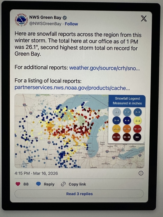
Wisconsin yesterday. I guess we should quite our bellyaching.
Tuesday, March 17th
A chilly but calm week ahead
Today, the winds die down slowly over the course of the day. A few clouds linger, but more sun than clouds. Chilly, high in the low 40s, chance of flurries today and tonight, overnight low in the mid 20s
Wednesday mostly sunny, calm winds, high around 40, overnight low in the upper 20s
Thursday brings sun and clouds mixed, high upper 40s, low mid 30s
Friday partly sunny, clouds may start filling in towards sunset, high a seasonal mid 50s, overnight low near 40
The weekend has a chance of showers.
Thanks, Max! Just picked up all my recycling from the front and side yard. Any idea what the weather will be like in 2 weeks? j/k kinda
ridski said:
Thanks, Max! Just picked up all my recycling from the front and side yard. Any idea what the weather will be like in 2 weeks? j/k kinda
Trend is currently for slightly warmer and dryer than average for the week of 3/30
Friday, March 20th
Periods of sun and rain this weekend
Today starts out sunny, then gathering clouds lead to likely evening and overnight rain. Breezy this afternoon. High mid 60⁰s low mid 40⁰s
Saturday clear, mostly sunny but again with clouds gathering later. High upper 50⁰s low around 40⁰
Sunday cloudy skies with rain at night, breezy, high mid 60⁰s low mid 40⁰s
Monday chance rain and colder over, high around 50⁰ low near freezing
Tuesday and Wednesday looking mild, chillier, some clouds, highs upper 40⁰s low mid 30⁰s

Sponsored Business


Promote your business here - Businesses get highlighted throughout the site and you can add a deal.


Starting a new month a couple of days early
Friday, Feb 27th
Some nicer days, then multiple chances of modest precipitation
Today and Saturday, sunny, highs around 50⁰, overnight lows around 30⁰. The big melt continues.
Sunday, chance of scattered snow showers, particularly in the morning. Little to no accumulation. High upper 30⁰s, low mid teens
Monday cloudy, could be icy in the morning where melted snow has frozen overnight. Very slight chance light snow in the morning, high upper 20⁰s low around 20⁰ so slippery conditions could persiste on untreated surfaces
Warmer weather (relatively speaking) returns next week. There are multiple chances for light precipitation, mostly rain, with the most likely being Tuesday night into Wednesday. Temps likely to stay above freezing throughout