Hurricane Florence and Potential Local Impacts


well - seems like a good time to review storm prep provisions/restock

Peak hurricane season is sufficient reason to keep basic provisions on hand just in case. Checking on one's neighbors is good advice hurricane or not.

Yeah, I'm going to stop today and grab a few basic things. Just the stuff with a long shelf life life like batteries and water.
Maybe Spam?


Wife: Could you do the egg bacon spam and sausage without the spam then?
Waitress: Urgghh!
Wife: What do you mean 'Urgghh'? I don't like spam!

More on Florence as she intensifies and may break some records

So crazy. I looked at Google News and the top story from 24 minutes ago is "Florence Strengthens to Category 4" while the next link below is "Florence Strengthens to Category 3" from an hour ago. Events are evolving quickly!

conandrob240 said:
nakaille said:? Wait, why? This isn’t supposed to affect our area in any significant way. Do you mean if they are in NC/SC?
Just take appropriate precautions, everyone! Know where your flashlights and batteries are, stock up only on real essentials (water, wine, whatever!) and be prepared to help your neighbors, friends and family.
They were saying to just think about it now, so that if something does come our way you'll already be prepared.
Often, when you decide you really need emergency supplies, it is too late to get them.

GoSlugs said:
Often, when you decide you really need emergency supplies, it is too late to get them.
Indeed, GoSlugs ! Here, in central North Carolina, with Florence still an estimated 4 days away, the stores are jammed. The bottled water shelves are empty, and the usual, "better get"s are dwindling fast. Many gas stations are out of gas too.
waxwingstwo said:
GoSlugs said:Indeed, GoSlugs ! Here, in central North Carolina, with Florence still an estimated 4 days away, the stores are jammed. The bottled water shelves are empty, and the usual, "better get"s are dwindling fast. Many gas stations are out of gas too.
Often, when you decide you really need emergency supplies, it is too late to get them.
Here, we have been hearing of mandatory evacuations in part of the Carolinas. Are you impacted by that?

The International Space Station's pics of Hurricane Florence.


WxNut2.0 said:
conandrob240 said:When this thread was initially started, there was a decent chance the storm made its way up towards us. Now it looks like we may just see some residual wind and rain over the weekend.
nakaille said:? Wait, why? This isn’t supposed to affect our area in any significant way. Do you mean if they are in NC/SC?
Just take appropriate precautions, everyone! Know where your flashlights and batteries are, stock up only on real essentials (water, wine, whatever!) and be prepared to help your neighbors, friends and family.
Ha!
11 PM: “ ... the guidance has AGAIN shifted a little to the RIGHT”!
Just how far is it from Durham to Newark?

WxNut,
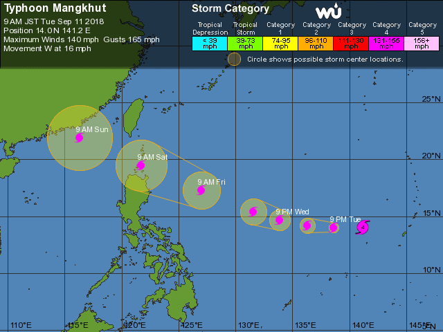
What do you make of typhoon Mangkhut headed our way in Hong Kong? Looks like a direct hit by (our) Sunday.
(think I'll make this a separate thread)

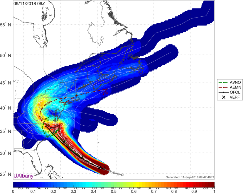
As of this morning's guidance Florence looks to make landfall as a cat 4 or 5 hurricane on Friday early morning, however it should be noted that winds out ahead of the storm will reach tropical storm level well as much as 24 hours before that.
There is a significant disagreement between the major models as to where landfall will be, with the GFS (and the NHC) placing landfall on the North Carolina coast, and the Euro placing it on the South Carolina coast. I'll let Wxnut chime in later and explain how and why I am oversimplifying, but IMHO the GFS tends to miss to the right (east) at this range in these conditions, so I am leaning more heavily on the Euro at this time. You can see on the NHC cone how it flairs out on Friday to show the wide area of possible effects. The bottom line, though, is that both models have many elements indicating a stall or a meander around the time of landfall that could keep the storm relatively stationary for up to 24 hours over and around the coast. That, coupled with a storm diameter that is already over 160 miles means that there will likely be a lot of rain and wind for a sustained period over a significant portion of the SE US coast.
Any effects locally will be limited at the first case to high surf, which is already being reported, and then later in the week we might see some rain, but nothing like tropical storm levels.
Neither Helene nor Isaac are significant threats to our area.
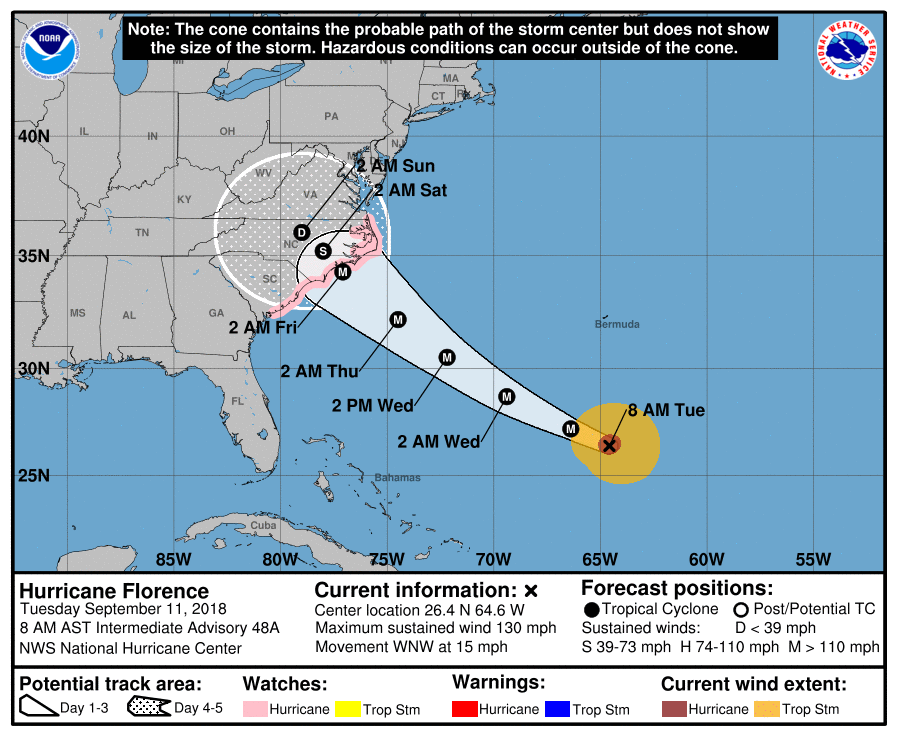
Images:
#1. Euro
#2. GFS
#3. NHC Cone
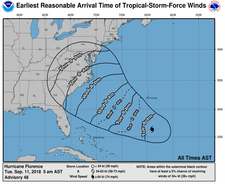
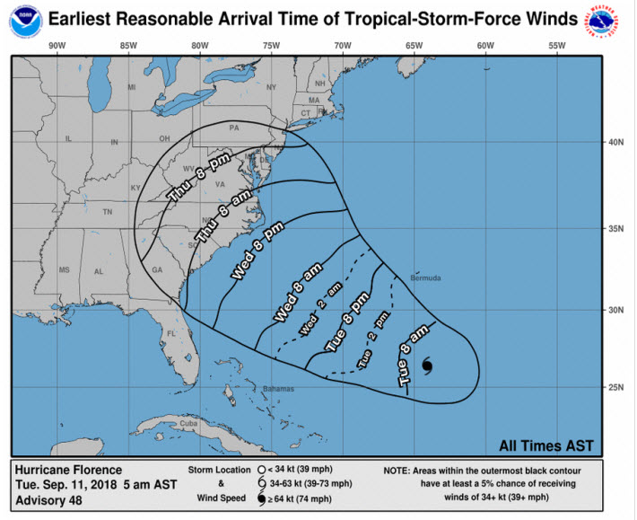
#4. NHC wind arrival predictions
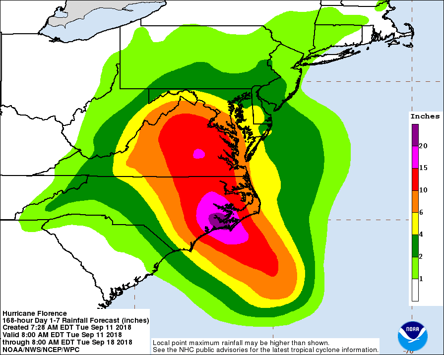
#5. Rain forecast showing 2+ feet of rain over widespread area near the coast.
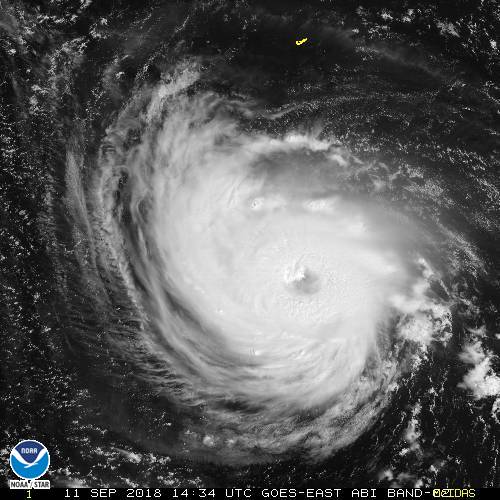
#6. Florence
joan_crystal said:
waxwingstwo said:Here, we have been hearing of mandatory evacuations in part of the Carolinas. Are you impacted by that?
GoSlugs said:Indeed, GoSlugs ! Here, in central North Carolina, with Florence still an estimated 4 days away, the stores are jammed. The bottled water shelves are empty, and the usual, "better get"s are dwindling fast. Many gas stations are out of gas too.
Often, when you decide you really need emergency supplies, it is too late to get them.
No, joan_crystal, we live well inland, about 30 miles west of Raleigh

Max,
In your fourth graphic, is that saying we could possibly be seeing tropical storm strength winds here in NJ Thursday night? I guess if the storm takes the most northerly track? (these different cones are confusing)
waxwingstwo said:
joan_crystal said:No, joan_crystal, we live well inland, about 30 miles west of Raleigh
waxwingstwo said:Here, we have been hearing of mandatory evacuations in part of the Carolinas. Are you impacted by that?
GoSlugs said:Indeed, GoSlugs ! Here, in central North Carolina, with Florence still an estimated 4 days away, the stores are jammed. The bottled water shelves are empty, and the usual, "better get"s are dwindling fast. Many gas stations are out of gas too.
Often, when you decide you really need emergency supplies, it is too late to get them.
Here, we are hearing that persons on the coast of the Carolinas are being advised to travel more that 100 miles west due to the size and intensity of the storm.
joan_crystal said:
waxwingstwo said:Here, we are hearing that persons on the coast of the Carolinas are being advised to travel more that 100 miles west due to the size and intensity of the storm.
joan_crystal said:No, joan_crystal, we live well inland, about 30 miles west of Raleigh
waxwingstwo said:Here, we have been hearing of mandatory evacuations in part of the Carolinas. Are you impacted by that?
GoSlugs said:Indeed, GoSlugs ! Here, in central North Carolina, with Florence still an estimated 4 days away, the stores are jammed. The bottled water shelves are empty, and the usual, "better get"s are dwindling fast. Many gas stations are out of gas too.
Often, when you decide you really need emergency supplies, it is too late to get them.
We live about 150 miles inland from the closest shore point. Our home is on a ridge top. While we do not expect flooding to be an issue, it looks fairly certain at this point that wind damage, particularly falling trees, is a real concern. We will be very lucky if none fall on our home.

joan_crystal said:
waxwingstwo said:Here, we are hearing that persons on the coast of the Carolinas are being advised to travel more that 100 miles west due to the size and intensity of the storm.
joan_crystal said:No, joan_crystal, we live well inland, about 30 miles west of Raleigh
waxwingstwo said:Here, we have been hearing of mandatory evacuations in part of the Carolinas. Are you impacted by that?
GoSlugs said:Indeed, GoSlugs ! Here, in central North Carolina, with Florence still an estimated 4 days away, the stores are jammed. The bottled water shelves are empty, and the usual, "better get"s are dwindling fast. Many gas stations are out of gas too.
Often, when you decide you really need emergency supplies, it is too late to get them.
Joan, just south of Myrtle Beach, and it's been VERY calm and quiet. Alot of folks have left. We're heading out in the morning, for Florida. I have not heard anything about going at least 100 miles inland.
drummerboy said:
Max,
In your fourth graphic, is that saying we could possibly be seeing tropical storm strength winds here in NJ Thursday night? I guess if the storm takes the most northerly track? (these different cones are confusing)
DB,
You have to overlay that one on the track, and allow for a radius of about 80 miles. Any track that would cause NJ to fall within the cone on the wind map is, at this time, a very low percentage solution. You are right, though, that graphic by itself is misleading. Next time I will draw the track on it. I really just wanted to show that the ETA for the storm was not landfall, that serious effects would occur around the likely track well before that.

Dave - Please make a separate thread so we can track that typhoon also.
max_weisenfeld said:
drummerboy said:DB,
Max,
In your fourth graphic, is that saying we could possibly be seeing tropical storm strength winds here in NJ Thursday night? I guess if the storm takes the most northerly track? (these different cones are confusing)
You have to overlay that one on the track, and allow for a radius of about 80 miles. Any track that would cause NJ to fall within the cone on the wind map is, at this time, a very low percentage solution. You are right, though, that graphic by itself is misleading. Next time I will draw the track on it. I really just wanted to show that the ETA for the storm was not landfall, that serious effects would occur around the likely track well before that.
gotcha

drummerboy said:
Max,
In your fourth graphic, is that saying we could possibly be seeing tropical storm strength winds here in NJ Thursday night? I guess if the storm takes the most northerly track? (these different cones are confusing)
Most cones give the 2/3 probability area that the eye will move through. ie, 66% chance that the eye will be within that cone.
The one you are highlighting is wider because it is showing the area that can potentially get trop storm winds, which of course extend out well from the eye.


drummerboy said:
I guess a cone is a cone is a cone, except when it's not.

My response initially and innocently stated that “your cone is bigger because” but I sensed the danger and edited.

Dennis_Seelbach said:Joan, just south of Myrtle Beach, and it's been VERY calm and quiet. Alot of folks have left. We're heading out in the morning, for Florida. I have not heard anything about going at least 100 miles inland.
Be safe.

Featured Events


Sponsored Business


Promote your business here - Businesses get highlighted throughout the site and you can add a deal.

When this thread was initially started, there was a decent chance the storm made its way up towards us. Now it looks like we may just see some residual wind and rain over the weekend.