WINTER STORM WARNING for Monday 12/2


conandrob240 said:
I wasn’t looking for certainty. Wanted to know if this was a Sunday, Monday, Tuesday, Weds thing. I didn’t see that info. So, looks like Sunday- Monday, right?
"From Sunday morning 12/1 through Monday night 12/2 the area will be affected by a winter storm."
Morning Forecast, Sunday 12/1
Winter Weather Advisory remains in effect.
Snow showers begin after 7:00am becoming a steady snow by 10:00am. Possible accumulation of an inch or two before changing to sleet, freezing rain, and finally all rain between 1:00 and 4:00pm. This will be the most difficult travel time here. The time or even the fact of this changeover will be different in other areas, with the weather significantly worse north and west.
Rain then likely to continue, light to moderate, through Sunday night and into Monday.
Rain likely to change back through freezing rain and sleet to snow Monday midday.
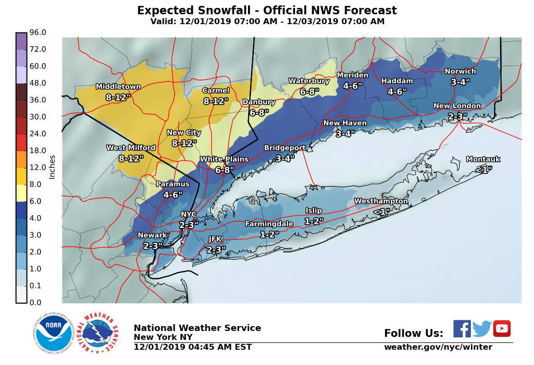
Snow then likely Monday through Monday night, with possibly 1" - 6" accumulation.
~~~~~~~~~~~~~~~~~
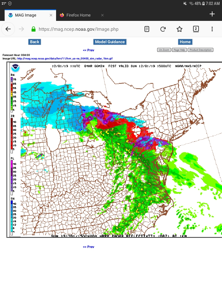
Models in decent agreement on the arrival of the main precipitation shield, arriving from the south west this morning (see screenshot below showing the main precipitation arriving around 10:00). Radar seems to indicate and the NWS agrees with a slightly earlier arrival.
There is still some uncertainty with today"s changeover timing, and more with the timing tomorrow, but the fact of winter weather, with some form of frozen precipitation over time, is inescapable.


ml1 said:
mrincredible said:
My personal prediction is nobody will be happy with whatever decision the school district makes Monday morning.
They'll either cancel school and people will gripe that it wasn't that bad, or school will happen and people will complain that it wasn't a safe decision.
Either way I have to drive to Galloway on Monday a.m. Hopefully the Parkway is well-managed.
100%
But the people who complain if school is canceled and the weather is a non-event should remember -- people went ballistic last November when the schools weren't canceled after a prediction of minor precipitation was followed by a complete transportation cluster when more snow than expected arrived.
And the people who went ballistic should understand that living north of FL, these things happen on occasion. Closing schools every time there is a threat of a snow flurry is not an option.


We're currently getting all the forms of winter precipitation at once in Lower Wyoming


Predicted trend I’m seeing is for warming, so I’m hopeful.
Jaytee said:
Morning commute might be bad.

susan1014 said:
Hopefully, but these storms always surprise as they move away. Could get 3 inches of snow.

conandrob240 said:
Saying mostly rain tomorrow now. Thoughts?
You ask a zillion questions with EVERY GD storm. Yes, it’s all about you. LOL
conandrob240 said:
Saying mostly rain tomorrow now. Thoughts?
Doesn't look like the temps will drop below 274 Kelvin tonight, so it seems the water will stay in its liquid form.

conandrob240 said:
Saying mostly rain tomorrow now. Thoughts?
If there’s gonna be substantial snow, it’ll be tomorrow. Some of the models show some pretty impressive snow rates, but I’m skeptical.
mrincredible said:
conandrob240 said:
Saying mostly rain tomorrow now. Thoughts?
Doesn't look like the temps will drop below 274 Kelvin tonight, so it seems the water will stay in its liquid form.
Evaporational cooling will probably aid in at least transient sub-freezing temps. That coupled with cold advection on the back side of the low should get the job done temperature wise. But again, I’m skeptical it’ll be enough to get really big totals.
WxNut2.0 said:
mrincredible said:
conandrob240 said:
Saying mostly rain tomorrow now. Thoughts?
Doesn't look like the temps will drop below 274 Kelvin tonight, so it seems the water will stay in its liquid form.
Evaporational cooling will probably aid in at least transient sub-freezing temps. That coupled with cold advection on the back side of the low should get the job done temperature wise. But again, I’m skeptical it’ll be enough to get really big totals.
But that band on the models....when I run the snowmap on the RGEM it shows 14 feet of snow!

max_weisenfeld said:
WxNut2.0 said:
mrincredible said:
conandrob240 said:
Saying mostly rain tomorrow now. Thoughts?
Doesn't look like the temps will drop below 274 Kelvin tonight, so it seems the water will stay in its liquid form.
Evaporational cooling will probably aid in at least transient sub-freezing temps. That coupled with cold advection on the back side of the low should get the job done temperature wise. But again, I’m skeptical it’ll be enough to get really big totals.
But that band on the models....when I run the snowmap on the RGEM it shows 14 feet of snow!
Not really! I am making fun of the weenies on the weather boards!
Sunday evening (12/1) actual forecast update.
Winter Weather Advisory has been extended by the NWS through all day Monday and into Tuesday early morning hours.
The storm is performing as forecast so far. While the early snow never hit the ground due to dry air at the mid levels, the sleet, ice, and rain arrived right on time. It has been all rain since about 4:00pm, and the temperature has been rising slowly.
Temperatures will continue to rise for another hour or three then hold steady most of the night.
Light rain will continue all night and into Monday morning. The heavier rain is moving off now to the northeast.
Tomorrow the day will start out with rain. Then things get complicated again, as the second phase of the storm begins to drop temperatures. The main point of difficulty in the forecast is a combination of the rate of precipitation and the drop in temperature. The two are connected -- heavier precipitation will drag colder air down from the upper levels and increase the amount of precipitation that falls as snow and sleet.
There is also the possibility of a heavy precipitation band forming somewhere west of the city. The models tend not to be able to forecast the formation of features like this band altogether accurately as they are too complex and localized. Although there have been signs of this band in several models, it is not possible at this time to predict when, where, or even if it will set up. If it does, it could be worth and extra 2 - 3" of snow.
Forecast for Monday, subject to variations as this is a difficult system to predict:
Rain in the morning.
Rain changes over to sleet and possibly freezing rain early Monday afternoon then to snow. Timing on the stages how heavy the precipitation will be for this period is not clear at this time.
Snow continues overnight, likely not too heavy after sunset.
Precipitation ends around daybreak.
SOMSD has a new Superintendent so all bets are off as to what his approach to snow days is. Not that I would dare to speculate any which way!
max_weisenfeld said:
max_weisenfeld said:
WxNut2.0 said:
mrincredible said:
conandrob240 said:
Saying mostly rain tomorrow now. Thoughts?
Doesn't look like the temps will drop below 274 Kelvin tonight, so it seems the water will stay in its liquid form.
Evaporational cooling will probably aid in at least transient sub-freezing temps. That coupled with cold advection on the back side of the low should get the job done temperature wise. But again, I’m skeptical it’ll be enough to get really big totals.
But that band on the models....when I run the snowmap on the RGEM it shows 14 feet of snow!
Not really! I am making fun of the weenies on the weather boards!
Probably explains why the HRDPS is out of its mind.
max_weisenfeld said:
Sunday evening (12/1) actual forecast update.
SOMSD has a new Superintendent so all bets are off as to what his approach to snow days is. Not that I would dare to speculate any which way!
Should be interesting for sure! It’s hard to call. Nothing? Delayed opening? Early close?
mammabear said:
conandrob240 said:
Saying mostly rain tomorrow now. Thoughts?
You ask a zillion questions with EVERY GD storm. Yes, it’s all about you. LOL
Actually they travel ALOT so would be affected by almost every storm...
Just noticed that the SOMSD schools website is announcing an early dismissal for Monday, 12/2 due to forecasted weather.

robinpr said:
Just noticed that the SOMSD schools website is announcing an early dismissal for Monday, 12/2 due to forecasted weather.
Just got the call. The only time mentioned was the 2pm closing of central administration.
I wouldn't be surprised if people thought (incorrectly) that 2pm is the early dismissal time.

sprout said:
Just got the call. The only time mentioned was the 2pm closing of central administration.
I wouldn't be surprised if people thought (incorrectly) that 2pm is the early dismissal time.
Well, people should really know their own kids school schedule. That's not asking too much.

According to the district website -is is an early dismissal on Monday. I wish it would post the times for each school.
EBennett said:
According to the district website - it is a 2pm dismissal on Monday.
The email said half day schedule. At SOMS that's 12:30.
Scully said:
mammabear said:
conandrob240 said:
Saying mostly rain tomorrow now. Thoughts?
You ask a zillion questions with EVERY GD storm. Yes, it’s all about you. LOL
Actually they travel ALOT so would be affected by almost every storm...
We all travel, have work, kids, etc. Not all of us ask specific questions with every freaking storm.

Featured Events
-
Stephen Whitty Presents - Hometown Movie Stars: The Celebrated Actors Of CHS
May 6, 2024 at 7:00pm


Yes