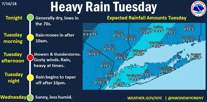
Heavy rain this afternoon (Tuesday, 7/17) as numerous thunderstorms cross the area leads to a Flash Flood Watch.

Flash Flood Watch
Flood Watch
National Weather Service New York NY
338 AM EDT Tue Jul 17 2018
...Flash Flooding Possible Today...
CTZ005>007-009-010-NJZ002-004-006-103>108-NYZ069>075-176>179-
172200-
/O.NEW.KOKX.FF.A.0004.180717T1600Z-180718T0200Z/
/00000.0.ER.000000T0000Z.000000T0000Z.000000T0000Z.OO/
Northern Fairfield-Northern New Haven-Northern Middlesex-
Southern Fairfield-Southern New Haven-Western Passaic-
Eastern Passaic-Hudson-Western Bergen-Eastern Bergen-
Western Essex-Eastern Essex-Western Union-Eastern Union-Rockland-
Northern Westchester-Southern Westchester-New York (Manhattan)-
Bronx-Richmond (Staten Island)-Kings (Brooklyn)-Northern Queens-
Northern Nassau-Southern Queens-Southern Nassau-
338 AM EDT Tue Jul 17 2018
...FLASH FLOOD WATCH IN EFFECT FROM NOON EDT TODAY THROUGH THIS
EVENING...
The National Weather Service in Upton has issued a
* Flash Flood Watch for portions of southern Connecticut,
northeast New Jersey, and southeast New York, including the
following areas, in southern Connecticut, Northern Fairfield,
Northern Middlesex, Northern New Haven, Southern Fairfield,
and Southern New Haven. In northeast New Jersey, Eastern
Bergen, Eastern Essex, Eastern Passaic, Eastern Union, Hudson,
Western Bergen, Western Essex, Western Passaic, and Western
Union. In southeast New York, Bronx, Kings (Brooklyn), New
York (Manhattan), Northern Nassau, Northern Queens, Northern
Westchester, Richmond (Staten Island), Rockland, Southern
Nassau, Southern Queens, and Southern Westchester.
* From noon EDT today through this evening
* A slow moving frontal system will bring numerous showers and
thunderstorms to the region this afternoon into this evening.
* Any thunderstorms will have the potential to bring torrential
downpours with rainfall rates of 1 to 2 inches per hour. These
types of rainfall rates will cause urban and poor drainage
flooding, with potential for flash flooding in areas affected by
multiple successive thunderstorms. Additionally, rapid water
level rises can occur on flashy small rivers and streams in
basins affected by this activity.
PRECAUTIONARY/PREPAREDNESS ACTIONS...
A Flash Flood Watch means that conditions may develop that lead
to flash flooding. Flash flooding is a very dangerous situation.
You should monitor later forecasts and be prepared to take action
should flash flood warnings be issued.


Thanks, Max. You helped me pack my umbrella and rainboots today before I left for work.

Yes, thank you Max for saving me from dragging the hose and sprinkler around the yard to water our flowers!


Max,
I have a flight out of Newark at 4:15 this afternoon. What flight delays are you projecting at this time? Secondly, what impact do you think these projected delays will have on the length of TSA screening lines in C Terminal?

tjohn said:
Max,
I have a flight out of Newark at 4:15 this afternoon. What flight delays are you projecting at this time? Secondly, what impact do you think these projected delays will have on the length of TSA screening lines in C Terminal?
When you land, let us know what you learned. 

For Sale
-

leather couches $300
More info


Garage Sales
-

Multi Family Garage Sale Sale Date: Apr 20, 2024
More info


Heavy rain this afternoon (Tuesday, 7/17) as numerous thunderstorms cross the area leads to a Flash Flood Watch. This means that the potential for heavy downpours can cause small streams to overrun their banks, and for ponding to temporarily flood streets and roads. Watch details in comments below.