Winter Weather Advisory for FREEZING RAIN this afternoon and tonight


Monday Dec 1st
First snowfall of the season possible Tuesday as a coastal low breezes through our area
Today, clear and chilly and a bit breezy. High near 40⁰ and overnight low in the upper 20⁰s. The breeze will make it feel colder
Tuesday brings a fast moving coastal storm. There is still some minor uncertainty on the exact track of the controlling low pressure, which could move the rain/snow line. The most likely scenario remains that the precipitation starts out as snow early Tuesday (not Thursday like I originally said) morning and changes over to rain by mid morning with a period of sleet in between. Accumulation in this scenario is 1 inch or less and gets washed away. The timing of precipitation is fairly solid but the exact timing of the changeover has some play in it. It is likely that the morning commute will be affected. Rain through the afternoon and possibly the early evening. High should make the low 40⁰s, low overnight upper 20⁰s so there is a chance of snow showers at the very end of the day, some puddles and untreated surfaces may freeze. Breezy overnight as the system departs
The above is the most likely scenario. Worst case is 2-3 inches of snow before changeover and still likely washed away. An all rain event is also possible
There are winter storm advisories and watches north and west of our immediate area but no advisories here so far
Wednesday mostly clear, high low 40⁰s low upper 20⁰s
Thursday partly cloudy and breezy, low 40⁰s upper 20⁰s
Keeping an eye on friday and the weekend for possible snow

max_weisenfeld said:
Monday Dec 1st
First snowfall of the season possible Tuesday as a coastal low breezes through our area
Today, clear and chilly and a bit breezy. High near 40⁰ and overnight low in the upper 20⁰s. The breeze will make it feel colder
Tuesday brings a fast moving coastal storm. There is still some minor uncertainty on the exact track of the controlling low pressure, which could move the rain/snow line. The most likely scenario remains that the precipitation starts out as snow early Thursday morning and changes over to rain by mid morning with a period of sleet in between. Accumulation in this scenario is 1 inch or less and gets washed away. The timing of precipitation is fairly solid but the exact timing of the changeover has some play in it. It is likely that the morning commute will be affected. Rain through the afternoon and possibly the early evening. High should make the low 40⁰s, low overnight upper 20⁰s so there is a chance of snow showers at the very end of the day, some puddles and untreated surfaces may freeze. Breezy overnight as the system departs
The above is the most likely scenario. Worst case is 2-3 inches of snow before changeover and still likely washed away. An all rain event is also possible
There are winter storm advisories and watches north and west of our immediate area but no advisories here so far
Wednesday mostly clear, high low 40⁰s low upper 20⁰s
Thursday partly cloudy and breezy, low 40⁰s upper 20⁰s
Keeping an eye on friday and the weekend for possible snow
Did you mean to write that the snow starts out early on "Tuesday" morning rather than "Thursday" morning?
joan_crystal said:
max_weisenfeld said:
Tuesday brings a fast moving coastal storm. There is still some minor uncertainty on the exact track of the controlling low pressure, which could move the rain/snow line. The most likely scenario remains that the precipitation starts out as snow early Thursday morning
Did you mean to write that the snow starts out early on "Tuesday" morning rather than "Thursday" morning?
Yes, thank you, I did
Corrected now
Tuesday Dec 2 update
Precipitation getting a late start this morning. With the daytime warming, this means less snow and a quicker changeover to rain. The rest of the forecast remains intact, with mixed snow and rain this morning changing over to all rain by mid morning. Rain ending late afternoon or early evening, tonight breezy and colder high around 40⁰ low tonight upper 20⁰s

Wed Dec 3rd
The NWS has issued a Special Weather Statement regarding the possibility of black ice this morning. Please be alert out there until things warm up a bit.
Today, mostly clear, high in the lower 40⁰s, overnight low in the upper 20⁰s
Thursday clouds move in, high in the upper 30⁰s. Then a shot of very cold air pushes through, breezy, with overnight lows in the teens
Friday will start out sunny but then a slight chance of snow showers but I doubt we'll see any accumulation. High around 30⁰ overnight low mid 20⁰s
Weekend starts out with a very slight chance of a snow shower but then both days look partly cloudy, high upper 30⁰s and low mid 20⁰s overnight
Friday Dec 5th
Today starts out cold, with mixed sun and clouds through the day until clouds take over towards evening. Slight chance of flurries with no accumulation. The low right now is in the 20⁰s rising to a high around 30⁰, then dropping back into the upper 20⁰s overnight
Saturday and Sunday partly sunny, not as cold, flurries possible but not very likely. Highs both days near 40⁰ lows mid 20⁰s
Monday colder again, sunny, high near 30⁰ but overnight low likely in the mid teens
Tuesday sun and clouds
Could see rain midweek


Thanks, Max! It is chilly out there. Saw a bit of ice on the side of the road today. Maybe from someone's sump-pump output.

Not to distract from the weather, but I find the sump pump sheets of ice can really cause you to slide if they're at a corner stop sign.
Monday Dec 8th
A hint of winter this week
Today, colder. Temps falling this morning into the mid 20⁰s and breezy, overnight low in the teens.
Tuesday clouds gathering, high just around freezing, overnight low just below freezing. Chance of light snow, accumulation unlikely.
Wed could see periods of light snow or mixed precipitation in the morning becoming likely all rain. Any accumulation should be washed away. Breezy, high lower 40⁰s low mid 30⁰s
Thursday and Friday mostly sunny highs upper 30⁰s low mid 20⁰s
Chance of snow overnight Friday into Saturday
Wed December 10th
Rain and breezy, then cold again
Today, breezy, light rain developing early this afternoon, ending tonight before the temperature drops. High today in the low 40⁰s but will feel colder, overnight low around 30⁰
Thursday quite breezy with gusts in the 30mph range, probably no rain or snow, mostly clear, likely won't get above freezing, low mid 20⁰s, the wind will make it feel colder
Friday and Saturday sun and clouds likely, high mid to upper 30⁰s, still breezy Friday. Might see light snow Saturday night into Sunday

2 to 4 inches of snow on Sunday morning? Maybe more? I just sent my snow blower to P&P to get it ready for the plowable snow we’re gonna have this winter. We’re overdue for some of the ‘90’s plowable snow storms.
Friday Dec 12th
First real snow of the season probable Sunday
Today, breezy, (mostly) clear and chilly, high in the low to mid 30⁰s but with the breeze should feel colder. Overnight low in the lower 20⁰s but the wind should die down by tonight
Saturday partly, cloudy high near 40⁰
Overnight Saturday to early Sunday morning, cold, low mid 20⁰s, gathering clouds then snow likely after midnight
Sunday, snow likely ends by mid morning. Total accumulation between 1 and 3 inches possible. Overnight low likely to also be Sunday's high as temps fall during the day into the mid to low 20⁰s and the breeze picks up again while the skies clear.
Sunday night clear and really cold, could very well see lows in the mid teens, breezy.
Monday partly cloudy and still pretty cold with highs only in the upper 20⁰s, overnight low near 20⁰
Tuesday, mostly sunny still likely cold with high right around the freezing mark

Saturday Dec 13th Update
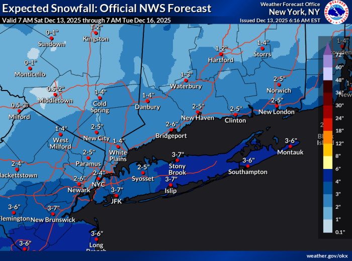
Winter Weather Advisory
The NWS has issued a Winter Weather Advisory for the entire area. 2 - 4 inches of snow is expected (NWS forecast has us at 2 - 6 inches so there is upside potential)
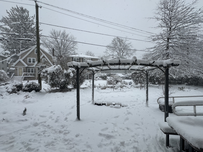
Clouds start moving in this morning and perhaps a quick shot of precipitation but the main event should come after midnight as temperatures fall and we see a steady snowfall that probably will continue through Sunday morning. Heaviest snowfall likely from around 1am until 6 or 7.
Midday Sunday snow should have ended and a breeze will pick up with gusts in the twenty mph range. Temps stay below freezing Sunday and likely Monday, too, so the snow should stick around for a day or two

Just did round 1 of 5 or 6. Snow is very heavy and yes, it is still coming down.


Batteries were charged, gone from the sidewalk in an hour..
Monday Dec 15th
Watch out for black ice this morning
The week starts out very cold today with a high in the upper 20⁰s and breezy. This afternoon clouds will move in but no precipitation. Overnight the wind dies down and the temperature drops down to the low 20⁰s and possibly into the teens as the sky clears
Tuesday partly cloudy and still cold with temps near or just below freezing and overnight lows in the mid 20⁰s
Wednesday things start to warm up, mostly sunny, high near 40⁰ but freezes again Wednesday night, lows mid 20⁰s
Thursday should start out with mixed sun and clouds, warmer, high near 50⁰. Overnight rain moves in, low in the 40⁰s
Friday rain could end early, high near 50⁰ again
Max, what I wanna know --- the bag of garbage that's been frozen on the bottom of the bin since last Tuesday, will it thaw by Friday?
Wed Dec 17th
Warmer weather today and rain before the weekend should clear most of the snow
Today, warmer, mostly sunny, high in the mid 40⁰s so some melting should happen. Overnight low in the upper 20⁰s could lead to icy patches in the morning Thursday
Thursday starts out mostly clear and warms up again, high could be near 50⁰ so more melting just be careful of ice early
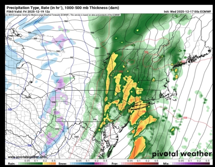
Overnight Thursday into Friday a squall line move through ahead of a front. Temps should actually rise overnight as rain and wind blow through after midnight. We could actually see (or hear) some thunder early Friday mornIng
Friday starts out with likely rain and maybe a bit of thunder. Likely quite windy, steady 20+ mph with gusts here near 40mph and higher in the city. Rain should end around midday but the wind could last all day as skies clear. High low to mid 50⁰s, overnight low near freezing
Saturday breezy more clouds gather but no rain likely high upper 30⁰s, Sunday much the same
Thursday December 18th
Update: the NWS has issued a Wind Advisory from midnight tonight through midnight Friday for steady winds in the mid 20mph range with gusts up to 50mph
The rest of the forecast is on track for showers thus evening and rain after midnight with chance of thunder through the morning commute
From the NWS:
111 AM EST Thu Dec 18 2025
...WIND ADVISORY REMAINS IN EFFECT FROM MIDNIGHT TONIGHT TO MIDNIGHT
EST FRIDAY NIGHT...
* WHAT...Southwest winds 15 to 25 mph with gusts up to 50 mph
expected.
* WHERE...Portions of southern Connecticut, northeastern New Jersey,
and southeastern New York.
* WHEN...From midnight tonight to midnight EST Friday Night.
* IMPACTS...Gusty winds will blow around unsecured objects. Tree
limbs could be blown down and a few power outages may result.
* ADDITIONAL DETAILS...Isolated wind gusts up to 60 mph are possible
Friday morning.
PRECAUTIONARY/PREPAREDNESS ACTIONS...
Winds this strong can make driving difficult, especially for high
profile vehicles. Use extra caution.
Secure outdoor objects.
&&

Batten down the hatches on Friday. This will be a wild front moving through. The temperature is going to drop 30 degrees.
Everyone okay?
I am awaiting my delayed flight to Newark from Florida.

Heard on the radio traffic report Route 10 is a disaster from Parsippany to beyond Roxbury, with wires down and traffic lights out. People had some crazy hail, too. Also, folks with inflatables in their yards have come home to find their decorations are on the run.
Monday, Dec 22
As of today, the days start getting longer 😁 tldr for travel this week is today dry, tomorrow morning light precipitation lasting through midday, wed likely dry, thursday light rain possible later in the day, Friday chance of rain
Details:
Today, sunny during the day, high upper 30⁰s. Light snow should develop overnight most likely well after midnight and lasting well into Tuesday morning. Overnight low around freezing
Tuesday starts out with light snow likely and mixes in light rain around midday. Might cause some slippery spots during the morning commute but widespread icing unlikely. Little accumulation of snow. High near 40⁰ as precipitation ends in the afternoon. Overnight low upper 30⁰s
Wednesday dry mostly clear and breezy, high in the lower 40⁰s, overnight clouds increase low near 30⁰
Christmas day cloudy, chance of light rain especially in the afternoon and evening, high in the lower 40⁰s overnight low mid 30⁰s

Tuesday afternoon update 12/23
Precipitation is ending, watch out for black ice tonight
As the front moves through this evening and precipitation ends the temperature will drop to right around freezing. With the high humidity the wet layer could freeze and create very slick conditions. Take it easy on the roads tonight
Tomorrow will be sunny and breezy with a high around 40, overnight could see some freezing but on the whole conditions should be dryer and icy conditions less likely
Might see a shower Christmas morning then clearing, wind dies down, high in the lower 40s. Overnight low in the lower 20sWe are looking at a likely winter weather event on Friday afternoon into Saturday. Details are still unclear as there is a disagreement in the models over where the low pressure center sits and therefore where the line between frozen precipitation and rain will be. Right now I would have to say 3 - 6" mixed snow and sleet with rain at the end but things could/will change between now and Friday, this is a very low confidence forecast. Will have a better answer in a couple of days

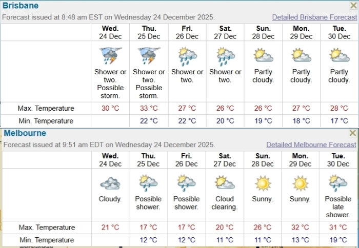
Just by way of diversion - and comparison - Brisbane is the capital city of the Australian state where Joanne lives, while Melbourne is the capital city of my home state.


Friday November 28th
A quiet weekend, then a complex system Tuesday
Today, breezy and clear. High lower 40s but the wind will make it feel colder. Low tonight around freezing
Saturday pretty much the same but without the wind
Sunday brings afternoon showers, high upper 40s low near freezing
Monday clear high lower 40s then cloudy overnight with the low near freezing
Tuesday. The models are in agreement that we are likely getting a storm. There is still significant disagreement over the track of the controlling low pressure, and from that the temperature profile, and from that what form the precipitation will take
The most likely scenario is a shot of snow mid morning that transitions through mixed precipitation to rain, but how long we will be seeing mixing (sleet, most likely) is not determined. In this result midday Tuesday is messy and rough driving but it resolves in rain by the afternoon rush.There are several alternative readings, including the unlikely possibility of a few inches of wet heavy snow followed by rain
This forecast will change over the next few days, we might not have a solid read before Monday morning