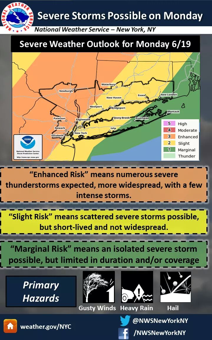
Severe Thunderstorms Watch now through this evening, Flash Flood Advisory

No hail, please. We were in St. Paul, Mn. a week ago and just a couple of miles from us hail was coming down in sheets and people were shoveling it away.

For Monday, a Flash Flood Watch has been added to the severe thunderstorm advisory. Yesterday's storm (0.66" in eastern Maplewood, 1.32" in Linden) caused street flooding in Union.
There is a Flash Flood Watch this afternoon and evening, with severe thunderstorms likely from late afternoon into tonight.
Be alert this afternoon and evening for quick developing and fast moving thunderstorms. Expect a Severe Storm Watch late this afternoon, possibly rising to a Warning. Storms in our area could drop 1 - 2+ inches of rain and contain damaging winds. Hail is a slight possibility.
From the NWS:
"Flash Flood Watch
Flood Watch
National Weather Service New York NY
338 AM EDT Mon Jun 19 2017
...HEAVY RAIN AND FLASH FLOODING POSSIBLE FROM THIS AFTERNOON
INTO TONIGHT...
...FLASH FLOOD WATCH REMAINS IN EFFECT FROM NOON EDT TODAY
THROUGH LATE TONIGHT...
The Flash Flood Watch continues for
* Portions of southern Connecticut, northeast New Jersey, and
southeast New York, including the following areas, in southern
Connecticut, Fairfield and New Haven. In northeast New Jersey,
Bergen, Essex, Hudson, Passaic and Union. In southeast New York,
Bronx, Kings (Brooklyn), Nassau, New York (Manhattan), Orange,
Putnam, Queens, Richmond (Staten Island), Rockland and
Westchester.
* From noon EDT today through late tonight.
* Numerous showers and thunderstorms are expected to develop
across the area from this afternoon into tonight ahead of a
slow moving cold front. Multiple rounds of thunderstorms have
the potential to move across the same area, leading to flash
flooding.
* Rainfall totals of 1 to 2 inches are expected across the watch
area, with locally higher amounts possible.
PRECAUTIONARY/PREPAREDNESS ACTIONS...
A Flash Flood Watch means that conditions may develop that lead
to flash flooding. Flash flooding is a very dangerous situation.
You should monitor later forecasts and be prepared to take action
should flash flood warnings be issued."


A Severe Thunderstorm Watch is not surprisingly in effect now until this evening.
Please be alert for warnings on your phone or device. Make sure that your device knows where you are so that you get accurate notices, at this time the cells are localized although by late afternoon we could see a full line come through ahead of this evening's cold front.
At this time, if you are watching the radar, the cells are coming from the southwest. Normally, our weather comes from the west/northwest, and the front itself will slowly move in from Pennsylvania later today. But there is lower level movement from the south, so look at Trenton/Cape May for what could be here in the short term.
From the NWS:
Severe Thunderstorm Watch
SEVERE THUNDERSTORM WATCH OUTLINE UPDATE FOR WS 354
NWS STORM PREDICTION CENTER NORMAN OK
1115 AM EDT MON JUN 19 2017
SEVERE THUNDERSTORM WATCH 354 IS IN EFFECT UNTIL 800 PM EDT
FOR THE FOLLOWING LOCATIONS
NJC003-013-017-019-021-023-027-031-035-037-039-041-200000-
/O.NEW.KWNS.SV.A.0354.170619T1515Z-170620T0000Z/
NJ
. NEW JERSEY COUNTIES INCLUDED ARE
BERGEN ESSEX HUDSON
HUNTERDON MERCER MIDDLESEX
MORRIS PASSAIC SOMERSET
SUSSEX UNION WARREN
There is a small thunderstorm headed our way. ETA about 1/2 hour or so. The main line of severe storms is now between Franklin NJ and Easton PA. Still a couple of hours away, although warnings are now up as close as Bernardsville and Morristown.


...and just like that, it's over. But don't worry, that's just a sample! 
My husband is sitting on a plane at Newark. They were supposed to take off three hours ago. Finally got in the queue to take off, then this happened.
But that was a great preview, as that storm that just brushed by us just hit warning level for Newark and NYC!
I got caught in it before it got here in Livingston. I had an umbrella but it didn't do any good. Hard to drive in, too.
FWIW, we are technically in the warning area, too, but the storm had already passed us by the time it hit warning criteria.

Next up shortly, a slightly larger warning-level storm. Let me know if you see hail!
From here on out, just assume these storms will continue for the next couple of hours. I have things to do, so I will not be announcing them individually. 
lash Flood Warning
NJC003-013-017-031-039-192345-
/O.NEW.KOKX.FF.W.0006.170619T2053Z-170619T2345Z/
/00000.0.ER.000000T0000Z.000000T0000Z.000000T0000Z.OO/
BULLETIN - EAS ACTIVATION REQUESTED
Flash Flood Warning
National Weather Service New York NY
453 PM EDT MON JUN 19 2017
The National Weather Service in Upton NY has issued a
* Flash Flood Warning for...  Hudson County in northeastern New Jersey...  Eastern Passaic County in northeastern New Jersey...  Union County in northeastern New Jersey...  Southern Bergen County in northeastern New Jersey...  Essex County in northeastern New Jersey...
* Until 745 PM EDT
* At 451 PM EDT, Doppler radar indicated thunderstorms producing  heavy rain approaching the warned area. Flash flooding is expected  to begin quickly due to the heavy rain, particularly in areas  where heavy rainfall has already occurred.
* Some locations that will experience flooding include...  Newark, Jersey City, Paterson, Elizabeth, Passaic, Bayonne, Wayne,  Hoboken, Plainfield, Bloomfield, Hackensack, Linden, Orange,  Bergenfield and Paramus.
Additional rainfall amounts of up to two inches are possible in the
warned area.
PRECAUTIONARY/PREPAREDNESS ACTIONS...
Excessive runoff from heavy rainfall will cause flooding of small
creeks and streams, urban areas, highways, streets and underpasses as
well as other drainage areas and low lying spots.
&&
With a little luck, that may have just been the worst of it, although expect rain, heavy at times, for awhile yet.
oots said:
yup
it did not go well!
max_weisenfeld said:
Oops, sorry, thought we had a bit more time!
 BTDT. Not very much fun...


Featured Events
-
Stephen Whitty Presents - Hometown Movie Stars: The Celebrated Actors Of CHS
May 6, 2024 at 7:00pm


Rentals
-
Huge Brand New construction Apartment in 2 family home with 4 bedrooms 3 bathrooms

4 Bd | 3Full Ba
$4,500

About a 50/50 chance as of now