Today, chance of showers, then showers likely. Warm again, bit of a breeze. Very slight chance of a thunderstorm. High in the upper 70⁰s again, overnight low mid 40⁰s
Thursday, comparatively chilly, with high only in the upper 40⁰s, mild breeze, showers possible all day, low mid 40⁰s
Friday, might see a shower in the morning, then more sun and warmer, high upper 60⁰s, low upper 50⁰s
Saturday starts out with some sun but then chance showers high upper 70⁰s low mid 50⁰s
Sunday looks like some rain, breezy, high near 70⁰. Timing details on the rain are still unclear
*Hag sameach and happy Passover to those who celebrate
Weekend weather probably warm and damp, with periods of sun and drizzle. Precise timing is uncertain, as there are multiple front passages. This is a "best try" forecast. The biggest unknown is temperature Sunday, as some models are as much as 10⁰ warmer for Sunday afternoon.
Today, warm and drizzle this morning, perhaps some fog. Clearing expected this afternoon, high in the lower 70⁰s, breezy in the afternoon, tonight dry, low around 60⁰
Saturday should start out partly sunny, high mid 70⁰s, then cloudy in the afternoon, chance of showers afternoon and evening, low in the lower 50⁰s
Sunday very likely showers and breezy, high in the 70⁰s, could hit 80⁰ if the sun breaks through, then clearing and cooler, overnight lows around 40⁰
The beginning of next week likely mostly sunny and seasonal, with highs in the mid 50⁰s and lows in the upper 30⁰s
The week starts out mostly sunny, breezy, and seasonably cool. Then nearer the weekend should be warmer, and there is the potential for a taste of summer
Today, more sun than cloud, quite breezy, high upper 50⁰s, overnight low around 40⁰
Tuesday, mostly clear, breezy, high around 50⁰, low around 30⁰
Wednesday, mild but chilly, high around 50⁰ overnight low mid 30s
Thursday should have some clouds but mostly sunny, mid 50⁰s, low lower 40⁰s
Friday and the weekend from here look mostly clear, calm, and warm, with highs around 70⁰ and lows in the 50⁰s but there is a wIde range in the temperature profile. The ocean is still quite cold so too much easterly breeze could drop the temps while a more southerly flow might bring warmer air
Here in Ocean County, we evidently had a real frost a day ago. (please excuse my unskilled attempts at commenting on weather) because a large planter of perennial hydrangeas, several years old, which had survived another winter, sprouting new growth, showing new buds, etc., and looking “healthy.” That all changed yesterday (still very chilly here) I found my hydrangea, now all brown, with its buds shriveled.
If the plant has another spring rejuvenation — if the weather actually warms up —I will report back!
Still warm this week, cooler weekend, some showers possible
Today, sunny and warm once the fog clears, high upper 80⁰s (warmer if we don't get the sea breeze this afternoon), tonight chance of showers and even a possible rumble of thunder, low in the mid 60⁰s
Thursday pretty much the same as today
Friday could be a bit cooler, only reaching the high 70⁰s or 80⁰, especially if we get an afternoon shower, low in the upper 50⁰s
Weekend looks cooler, sun and clouds Saturday, showers likely Sunday. Highs upper 60⁰s, overnight lows 50⁰s
Here in Ocean County, we evidently had a real frost a day ago. (please excuse my unskilled attempts at commenting on weather) because a large planter of perennial hydrangeas, several years old, which had survived another winter, sprouting new growth, showing new buds, etc., and looking “healthy.” That all changed yesterday (still very chilly here) I found my hydrangea, now all brown, with its buds shriveled.
If the plant has another spring rejuvenation — if the weather actually warms up —I will report back!
yes, here too. it killed the bloom on my neighbor's magnolia
Tonight there are still some showers in the area but nothing serious, though may get a bit breezy. Low in the upper 30s
Monday might have some lingering showers in the morning, then more sun and a high in the low 50s
Monday night clear skies and a bit of a breeze should drive temps into the low 30s. The NWS has issued a freeze warning for our area
Tuesday will continue unseasonably cold with sunny skies but a high only in the mid 50s. Clouds likely to gather Tuesday night, low mid 40s and a chance of a shower
Wednesday we could start to see a bit of a warming trend, partly sunny and high in the low 60s. Wednesday night clearing and a low in the mid 40s
Thursday lots of moving parts but could be a really nice day with a potential high near 70. Overnight low around 50
Friday could also be sunny and also hit 70
Then into the weekend, it's a bit of a crapshoot with a 50/50 chance of showers both days and likely seasonal temps in the 60s by day and mid 40s at night
~~~~~~~~~~~~~~~~~
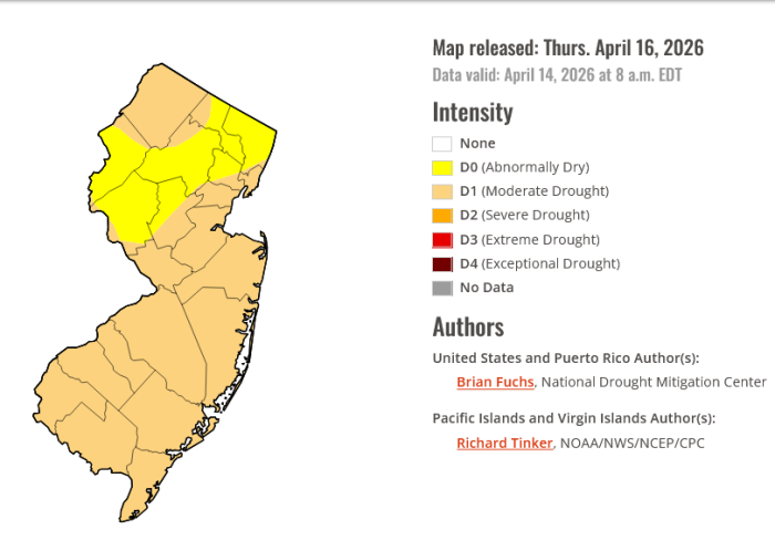
If you follow the local gardening groups it should be no shock to hear that the entire state remains in drought or near drought conditions, with our specific area being in a D1 (moderate drought) status. This is unlikely to change, except possibly to get worse, over the next few weeks. Unfortunately that one big snowstorm did little to offset months of low rainfall, and since then things have continued to be relatively dry. In a few weeks we will be heading into fire season and it will become very important to be sensible and careful with outdoor fires, including fire pits and such, even in our back yards.
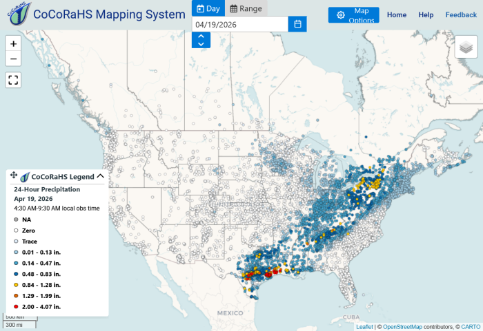
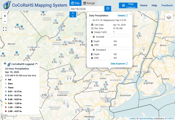
In other news, the NWS is looking for rainfall observers. It's an easy gig and it can be really cool to find your observations cited in NWS reports after storms. Details are here: https://www.cocorahs.org/Content.aspx?page=aboutus
Showers and cool temps with one glorious day thrown in.
Today, the showers will be ending later this morning, but the clouds will remain around all day. High upper 50s, overnight low mid 40s
Thursday should be mostly sunny, high in the low 70s, mostly just a light breeze but there is a possibility of some modest gusting. Low near 50. The downside is a possibility of there being a fire risk with dry air and a breeze and our current drought conditions
Friday mixed sun and clouds and back to cool temps with highs in the low 60s and lows near 50
The weekend is still a toss up as to whether the precipitation reaches us or stays to our north. Either way it will be cooler with temps in the 50s to low 60s and a 50/50 chance of showers, more likely on Saturday than Sunday
The Week Ahead -- Mother Nature and the Three Bears. Too warm, too wet, too cold
Monday, sunny with a high in the lower 70s. Breezy. Overnight low around 60. The NWS might issue a fire watch for Monday, as warm, dry weather and gusty winds will dry out the brush and the conditions could be ripe for fire
Tuesday, some clouds and unseasonably warm, with a high in the lower 80s likely. Slight chance of thundershowers. Overnight low near 60
Wednesday, showers likely, all day and most of the night. High near 70 and overnight low near 50
Thursday showers still likely, high near 60 low lower 40s
Friday and the weekend might have showers and are likely to be a bit colder than normal with highs in the low 60s
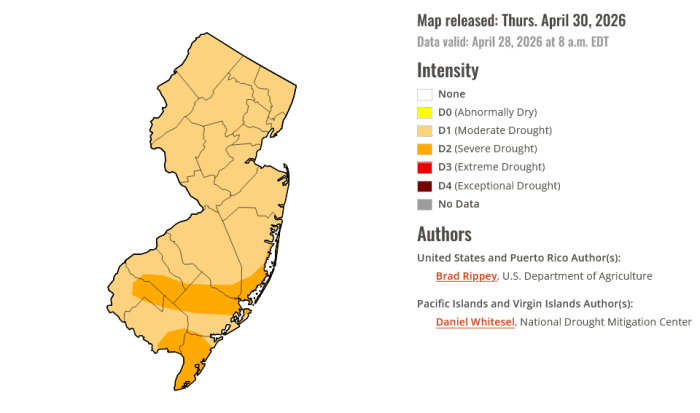
Despite the recent rain, the whole state is and is likely to remain in a moderate drought condition and care should be taken with outdoor activities involving fire
Here in Ocean County, I still wear a sweater outdoors due to the cool wind that even accompanies the days when the sun shines brightly. My pots of perennials are showing signs of life, but at this point in time they are pretty puny for May.
Tonight, the showers are pretty much over. Some clearing, low around 50
Tomorrow (Monday), mixed sun and clouds, high mid 60s. Overnight more clouds, low mid 40s
Tuesday could be the nicest day of the week, with ample sun likely and highs in the upper 60s (might even hit 70)
...and the rest of the week is a crap shoot, with mostly cloudy days with highs in the upper 60s, showers likely, some periods of cloudy and dry, overnight lows in the lower 50s
From here the weekend is looking better, with a distinct possibility of sunny and warm. Fingers crossed! 🤞
Then clear and warming for the weekend, with highs Saturday near 80⁰, and Sunday in the upper 80⁰s. Clear and unseasonably warm weather likely continues into early next week
One note, the NWS wants to remind you that water temperatures are still in the 50⁰s so be careful boating or at the beach this weekend


 Mothers Day is a washout then?


Wed April 1
Chance of frogs this afternoon and evening*
Today, chance of showers, then showers likely. Warm again, bit of a breeze. Very slight chance of a thunderstorm. High in the upper 70⁰s again, overnight low mid 40⁰s
Thursday, comparatively chilly, with high only in the upper 40⁰s, mild breeze, showers possible all day, low mid 40⁰s
Friday, might see a shower in the morning, then more sun and warmer, high upper 60⁰s, low upper 50⁰s
Saturday starts out with some sun but then chance showers high upper 70⁰s low mid 50⁰s
Sunday looks like some rain, breezy, high near 70⁰. Timing details on the rain are still unclear
*Hag sameach and happy Passover to those who celebrate