Flood Advisory; Flash Flood Watch. Elsa Fri 7/9


Update 7/6
The NWS has issued a Heat Advisory for today and tomorrow. Afternoon high Temps in the mid to high 90s with a heat index ("feels like") temp near or over 100.
This afternoon, Tues, there is a good chance of thunderstorms, most likely from 5 to 9pm. There is a slight chance that a thunderstorm could bring gusty winds.
Thunderstorms are also possible tomorrow and Thurs.
~~~~~~~~~~~~~~~~
From the National Weather Service:
CTZ009-NJZ004-006-103>108-NYZ069>071-177-179-062030-
/O.CON.KOKX.HT.Y.0003.210706T1500Z-210708T0000Z/
Southern Fairfield-Eastern Passaic-Hudson-Western Bergen-
Eastern Bergen-Western Essex-Eastern Essex-Western Union-
Eastern Union-Rockland-Northern Westchester-Southern Westchester-
Northern Nassau-Southern Nassau-
406 AM EDT Tue Jul 6 2021
...HEAT ADVISORY REMAINS IN EFFECT FROM 11 AM THIS MORNING TO
8 PM EDT WEDNESDAY...
* WHAT...Heat index values up to lower 100s.
* WHERE...Portions of northeast New Jersey and southeast New
York.
* WHEN...From 11 AM Tuesday to 8 PM EDT Wednesday.
* IMPACTS...Hot temperatures and high humidity may cause heat
illnesses to occur.
* ADDITIONAL DETAILS...The highest temperatures and heat indices
are expected between 1 PM and 5 PM each afternoon.
PRECAUTIONARY/PREPAREDNESS ACTIONS...
A Heat Advisory is issued when the combination of heat and
humidity is expected to make it feel like it is 95 to 99 degrees
for two or more consecutive days, or 100 to 104 degrees for any
length of time.
Seniors and those with chronic health problems or mental health
conditions are at an increased risk. Homes without air
conditioning can be much hotter than outdoor temperatures.
Use air conditioning to stay cool at home or go to a place that
has air conditioning. Check on vulnerable friends, family members
and neighbors.
To reduce risk during outdoor work, the Occupational Safety and
Health Administration recommends scheduling frequent rest breaks
in shaded or air conditioned environments. Anyone overcome by
heat should be moved to a cool and shaded location. Heat stroke
is an emergency! In cases of heat stroke call 9 1 1.
&&

Severe Thunderstorm Watch for this afternoon (Tues July 6) and evening until 10pm.
A thunderstorm watch means there is a possibility of severe thunderstorms -- in this case, about 50/50. A severe thunderstorm is a thunderstorm that could have damaging winds, rain, or hail. It is more of a storm than just some noise and water. In this case, a line of thunderstorms with the potential to become severe is developing in southeast New York State that will arrive here in 1 - 3 hours, coming from the north.
Should a severe storm start to develop, the NWS will issue a Severe Thunderstorm Warning -- this is the alert you might get on your phone if you have the setting turned on. These warnings come up quickly, often only minutes before a storm hits, so please do not depend on this facebook page (or any facebook page) to get these warnings in a timely manner.

Severe Thunderstorm Warning
Severe Thunderstorm Warning
NJC003-013-017-031-039-NYC005-047-061-071-081-085-087-119-062230-
/O.NEW.KOKX.SV.W.0037.210706T2153Z-210706T2230Z/

BULLETIN - IMMEDIATE BROADCAST REQUESTED
Severe Thunderstorm Warning
National Weather Service New York NY
553 PM EDT Tue Jul 6 2021

The National Weather Service in Upton NY has issued a

* Severe Thunderstorm Warning for...
  Hudson County in northeast New Jersey...
  Passaic County in northeast New Jersey...
  Union County in northeast New Jersey...
  Bergen County in northeast New Jersey...
  Essex County in northeast New Jersey...
  Southeastern Orange County in southeast New York...
  Queens County in southeast New York...
  Richmond County in southeast New York...
  Bronx County in southeast New York...
  Kings County in southeast New York...
  Rockland County in southeast New York...
  Southern Westchester County in southeast New York...
  New York (Manhattan) County in southeast New York...

* Until 630 PM EDT.

* At 549 PM EDT, severe thunderstorms were located along a line
  extending from near Vernon Valley to near Lake Telemark to near
  Chester, moving east at 55 mph.

  HAZARD...70 mph wind gusts.

  SOURCE...Radar indicated.

  IMPACT...Expect considerable tree damage. Damage is likely to
           mobile homes, outbuildings.

* Severe thunderstorms will be near...
  Bloomingdale around 555 PM EDT.
  Wayne, Ringwood, Pompton Lakes, Fairfield and Greenwood Lake
  around 600 PM EDT.
  Sloatsburg and Hawthorne around 605 PM EDT.
  Paterson, Paramus, Summit, and Caldwell around 610 PM EDT.
  Bloomfield and Hackensack around 615 PM EDT.
  Newark, Ridgefield, Harlem and Riverdale around 620 PM EDT.
  Jersey City, Yonkers, Bayonne, and Secaucus around 625 PM EDT.
  Flatbush, Flushing, Hoboken, Coney Island, Crown Heights,
  the Throgs Neck Bridge and Midtown Manhattan around 630 PM EDT.

PRECAUTIONARY/PREPAREDNESS ACTIONS...

For your protection move to an interior room on the lowest floor of a
building.

Damaging winds and continuous cloud to ground lightning are
occurring with these storms. Move indoors immediately. Remember, if
you can hear thunder, you are close enough to be struck by
lightning.

&&

LAT...LON 4060 7422 4060 7446 4066 7440 4067 7446
      4076 7436 4090 7434 4091 7427 4100 7430
      4104 7450 4109 7450 4120 7437 4131 7453
      4119 7353 4110 7373 4100 7364 4082 7379
      4074 7370 4054 7391 4060 7403 4050 7425
TIME...MOT...LOC 2149Z 284DEG 47KT 4123 7444 4098 7446 4082 7468

HAIL...<.75IN
WIND...70MPH


Wow! I was in Maplewood Village and it kicked up pretty suddenly.

Wed July 7
Today, Heat Advisory continues until 10pm tonight.
Chance of thunderstorms again this afternoon and evening.
Thurs/Fri, heavy rain is possible as tropical storm Elsa passes
~~~~~~~~~~~~~~
From the NWS:
Heat Advisory
URGENT - WEATHER MESSAGE
National Weather Service New York NY
429 AM EDT Wed Jul 7 2021
CTZ005>007-009-010-NJZ002-004-006-103>108-NYZ067>071-078-080-177-
179-072000-
/O.CON.KOKX.HT.Y.0003.000000T0000Z-210708T0000Z/
Northern Fairfield-Northern New Haven-Northern Middlesex-
Southern Fairfield-Southern New Haven-Western Passaic-
Eastern Passaic-Hudson-Western Bergen-Eastern Bergen-
Western Essex-Eastern Essex-Western Union-Eastern Union-Orange-
Putnam-Rockland-Northern Westchester-Southern Westchester-
Northwest Suffolk-Southwest Suffolk-Northern Nassau-
Southern Nassau-
429 AM EDT Wed Jul 7 2021
...HEAT ADVISORY REMAINS IN EFFECT UNTIL 8 PM EDT THIS EVENING...
* WHAT...Heat index values up to 101.
* WHERE...Portions of northeast New Jersey, southern Connecticut
and southeast New York.
* WHEN...Until 8 PM EDT this evening.
* IMPACTS...Hot temperatures and high humidity may cause heat
illnesses to occur.
PRECAUTIONARY/PREPAREDNESS ACTIONS...
A Heat Advisory is issued when the combination of heat and
humidity is expected to make it feel like it is 95 to 99 degrees
for two or more consecutive days, or 100 to 104 degrees for any
length of time.
Seniors and those with chronic health problems or mental health
conditions are at an increased risk. Homes without air
conditioning can be much hotter than outdoor temperatures.
Use air conditioning to stay cool at home or go to a place that
has air conditioning. Check on vulnerable friends, family members
and neighbors.
To reduce risk during outdoor work, the Occupational Safety and
Health Administration recommends scheduling frequent rest breaks
in shaded or air conditioned environments. Anyone overcome by
heat should be moved to a cool and shaded location. Heat stroke
is an emergency! In cases of heat stroke call 9 1 1.
&&
$$
7/7 Afternoon update
Severe Thunderstorm Watch for our area until 11pm tonight
Conditions exist that are conducive to thunderstorm development, especially from 5 - 9pm
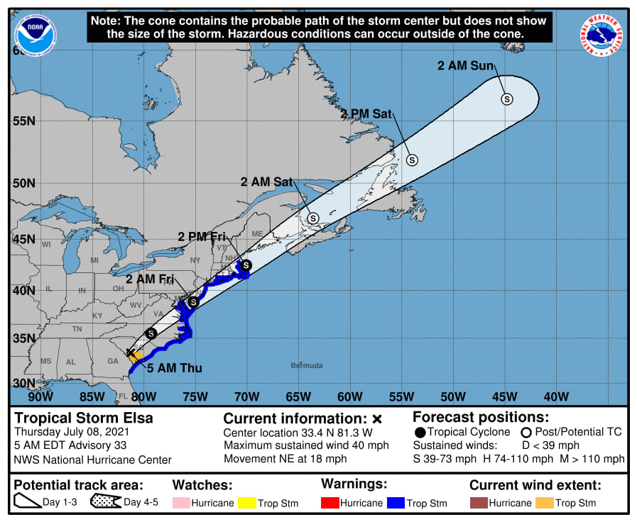
Elsa update:
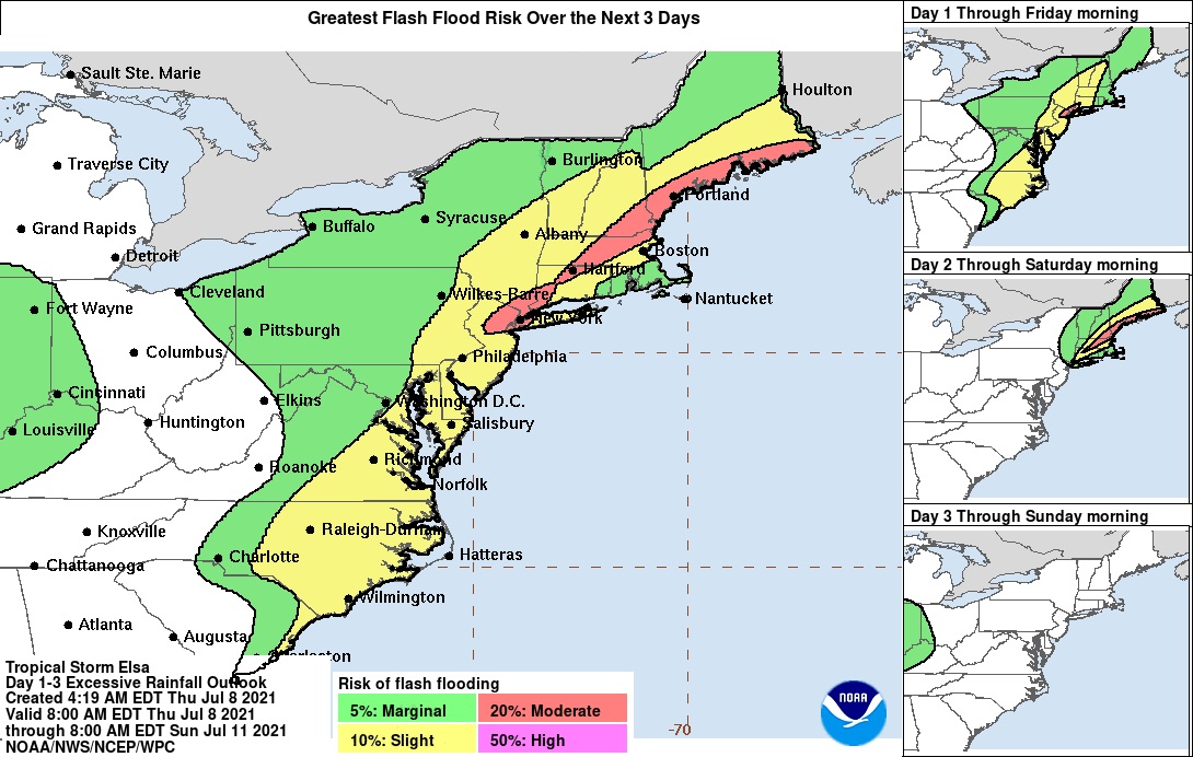
The NWS has issued a flash Flood Watch for Thursday Night and Friday
Flash Flood Watch
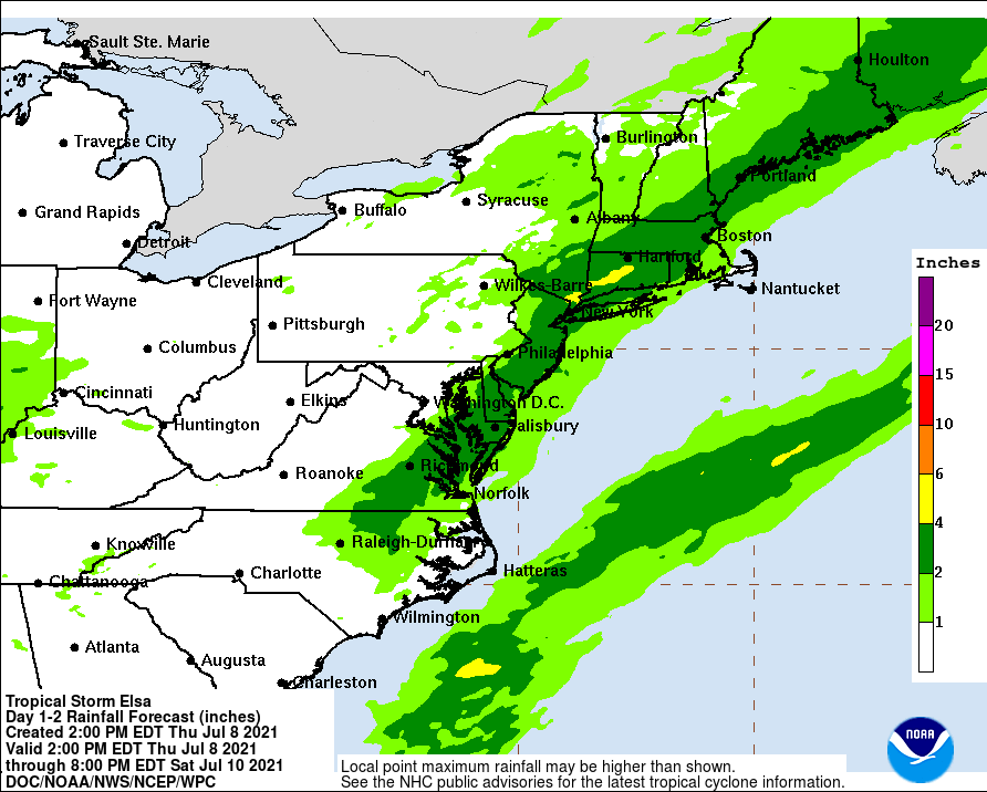
Flood Watch
National Weather Service New York NY
428 PM EDT Wed Jul 7 2021


CTZ005-006-009-010-NJZ002-004-006-103>108-NYZ067>075-176>179-
081000-
/O.NEW.KOKX.FF.A.0002.210709T0400Z-210709T1600Z/
/00000.0.ER.000000T0000Z.000000T0000Z.000000T0000Z.OO/
Northern Fairfield-Northern New Haven-Southern Fairfield-
Southern New Haven-Western Passaic-Eastern Passaic-Hudson-
Western Bergen-Eastern Bergen-Western Essex-Eastern Essex-
Western Union-Eastern Union-Orange-Putnam-Rockland-
Northern Westchester-Southern Westchester-New York (Manhattan)-
Bronx-Richmond (Staten Island)-Kings (Brooklyn)-Northern Queens-
Northern Nassau-Southern Queens-Southern Nassau-
428 PM EDT Wed Jul 7 2021

...FLASH FLOOD WATCH IN EFFECT FROM LATE THURSDAY NIGHT THROUGH
FRIDAY MORNING...

The National Weather Service in Upton has issued a

* Flash Flood Watch for portions of southern Connecticut,
  northeast New Jersey, and southeast New York, including the
  following areas, in southern Connecticut, Northern Fairfield,
  Northern New Haven, Southern Fairfield, and Southern New
  Haven. In northeast New Jersey, Eastern Bergen, Eastern Essex,
  Eastern Passaic, Eastern Union, Hudson, Western Bergen,
  Western Essex, Western Passaic, and Western Union. In
  southeast New York, Bronx, Kings (Brooklyn), New York
  (Manhattan), Northern Nassau, Northern Queens, Northern
  Westchester, Orange, Putnam, Richmond (Staten Island),
  Rockland, Southern Nassau, Southern Queens, and Southern
  Westchester.

* From late Thursday night through Friday morning

* Heavy rainfall ahead of tropical system Elsa will move into
  portions of the Tri-State area late Thursday night, with periods
  of heavy rainfall possible through Friday morning. Although
  heavy rainfall will be possible as early as Thursday afternoon,
  the greater chances for this will begin Thursday night. Total
  rainfall from Thursday afternoon through Friday is expected to
  range mostly 2 to 3 inches, with locally higher amounts
  possible.

* Heavy rain may cause some smaller rivers and streams to quickly
  rise out of their banks. There is also the potential for flash
  flooding in areas of poor drainage.

PRECAUTIONARY/PREPAREDNESS ACTIONS...

A Flash Flood Watch means that conditions may develop that lead
to flash flooding. Flash flooding is a very dangerous situation.
You should monitor later forecasts and be prepared to take action
should flash flood warnings be issued.

&&

$
Why is it always when I will be traveling? And I don't travel very often.
Thanks, Max!

Heavy Rain Tonight, Thursday July 8, in advance of the remnants of tropical storm Elsa.
Not as hot today. Chance of showers or thunderstorms during the day, becoming more likely towards evening.
Tonight, heavy rain likely as tropical storm Elsa passes close to our south and east. The NWS has issued a Flash Flood Watch for tonight and Friday morning. Heavy rain may impact the commute Friday morning. Although high wind is not the headline feature in the immediate MAPSO area, the potential exists for localized cells to produce strong gusts.
Severe Thunderstorm Watch
Thurs July 8th - Friday July 9th
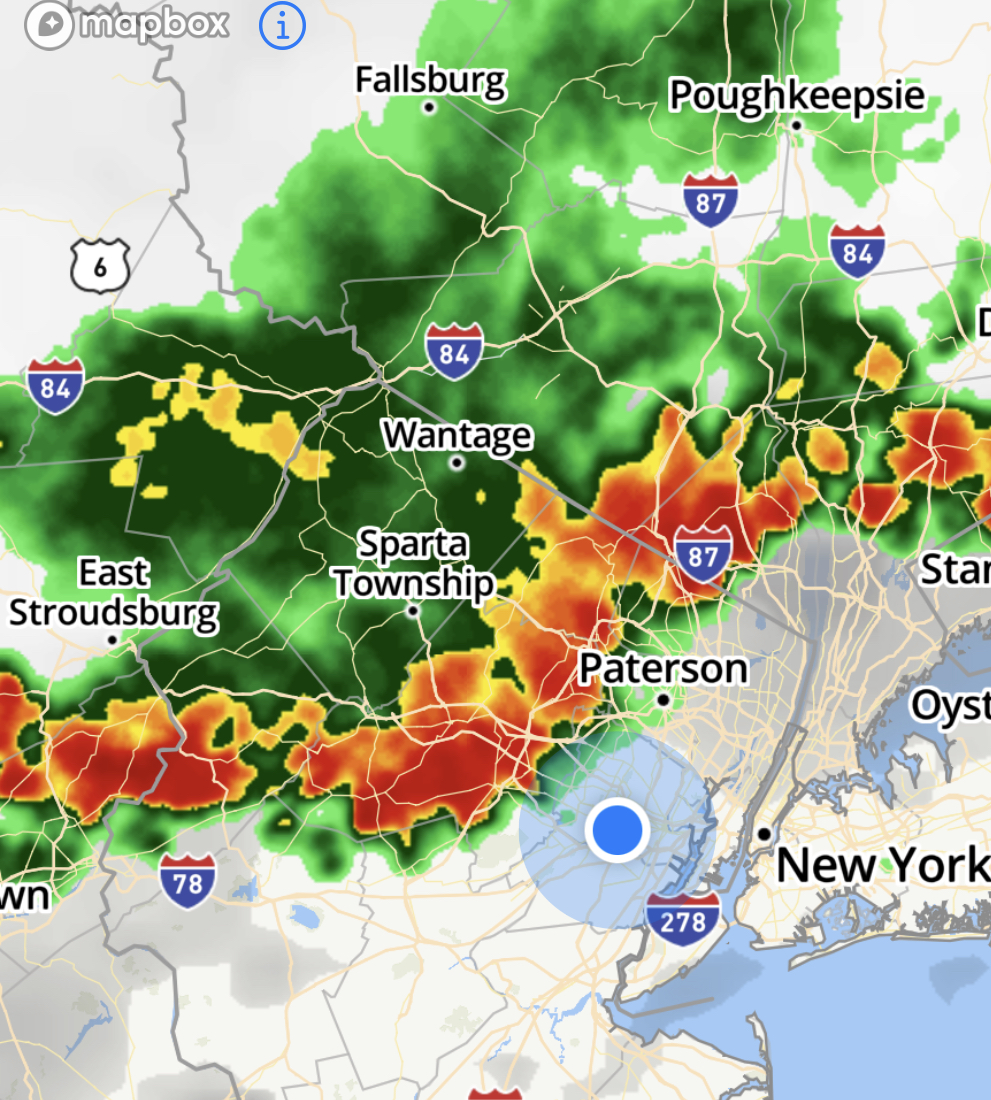
There are thunderstorms in the area now and there will likely continue to be showers and thunderstorms straight through until tomorrow morning.
Rain is likely to get heavy tonight as this current system interacts with the passage of Elsa to our south and east early tomorrow morning
2 - 4 inches of rain in the next 18 hours
ETA I know the graphic runs through Saturday but the bulk of the precipitation is likely to fall between now and mid-morning tomorrow


We're flying home from Southern California tomorrow afternoon. I wonder whether we need to reschedule our flight, or will Elsa have subsided by the time we land Friday evening?

sac said:
So we will be all done with it by lunchtime tomorrow?
It's complicated when you have a tropical storm involved
Fri, July 9
Rain continues this morning as Elsa passes to our east just offshore. Heavy rain through mid morning, then chance of showers through tonight. Slight chance of a back end thunderstorm this afternoon or early evening.
Flash Flood Watch and Flood Advisory still in effect today.
Although MAPSO has and will avoid the worst of this storm,, and wind here has not been much of a factor,, Elsa has had significant effects (and will continue to do so) in our area, especially overnight at the Jersey Shore. Possible tornado was reported near Beach Haven and a water spout near Pt Pleasant. Expect heavy rain and wind on the south shore of Long Island this morning. Travel throughout the region could be difficult.

Yesterday afternoon I went to the PSEG power outage map just to see what was going on in the area and within seconds our power went out (for five minutes).

Rentals

Sponsored Business


Promote your business here - Businesses get highlighted throughout the site and you can add a deal.

Heat Advisory Tuesday, July 6, and possibly Wed July 7
Daytime Temps will be in the mid 90s with heat indexes near or above 100° both days.
Tues and Wed also expect there could be thunderstorm activity in the afternoons.
Elsa remnants possible Thursday but mostly as rain.
~~~~~~~~~~~~~~~~
From the National Weather Service:
Heat Advisory
URGENT - WEATHER MESSAGE
National Weather Service New York NY
408 AM EDT Mon Jul 5 2021
NJZ004-006-103>108-NYZ069>071-177-179-052030-
/O.NEW.KOKX.HT.Y.0003.210706T1500Z-210707T0000Z/
Eastern Passaic-Hudson-Western Bergen-Eastern Bergen-
Western Essex-Eastern Essex-Western Union-Eastern Union-Rockland-
Northern Westchester-Southern Westchester-Northern Nassau-
Southern Nassau-
408 AM EDT Mon Jul 5 2021
...HEAT ADVISORY IN EFFECT FROM 11 AM TO 8 PM EDT TUESDAY...
* WHAT...Heat index values up to 102 expected.
* WHERE...Portions of northeast New Jersey and southeast New
York.
* WHEN...From 11 AM to 8 PM EDT Tuesday.
* IMPACTS...Hot temperatures and high humidity may cause heat
illnesses to occur.
* ADDITIONAL DETAILS...Highest temperatures and heat indices
between 1 PM and 5 PM Tuesday afternoon.
PRECAUTIONARY/PREPAREDNESS ACTIONS...
A Heat Advisory is issued when the combination of heat and
humidity is expected to make it feel like it is 95 to 99 degrees
for two or more consecutive days, or 100 to 104 degrees for any
length of time.
Seniors and those with chronic health problems or mental health
conditions are at an increased risk. Homes without air
conditioning can be much hotter than outdoor temperatures.
Use air conditioning to stay cool at home or go to a place that
has air conditioning. Check on vulnerable friends, family members
and neighbors.
To reduce risk during outdoor work, the Occupational Safety and
Health Administration recommends scheduling frequent rest breaks
in shaded or air conditioned environments. Anyone overcome by
heat should be moved to a cool and shaded location. Heat stroke
is an emergency! In cases of heat stroke call 9 1 1.
eat stroke call 9 1 1.
&&