Winter Weather Advisory Monday 2/22 for 2" - 4" of !@#$%&* Snow


tomcat said:
Couple of years ago, I saw a juvenile cardinal begging for food from an adult male. He relented, and fed it on the ground under the feeder.
Remaining photos are 'crisper' reds. Ringneck pheasant, golden pheasant (Turtleback Zoo) and red ibis (Central Park Zoo & Bronx Zoo). Lastly a red macaw, seen at an orchid show in Florida.
Hey @tomcat, I'm thinking you were planning on posting on the Valentine's day Uncaged Bird thread. They are gorgeous and if you get a chance, share them with the bird lovers!

Morganna said:
tomcat said:
Couple of years ago, I saw a juvenile cardinal begging for food from an adult male. He relented, and fed it on the ground under the feeder.
Remaining photos are 'crisper' reds. Ringneck pheasant, golden pheasant (Turtleback Zoo) and red ibis (Central Park Zoo & Bronx Zoo). Lastly a red macaw, seen at an orchid show in Florida.
Hey @tomcat, I'm thinking you were planning on posting on the Valentine's day Uncaged Bird thread. They are gorgeous and if you get a chance, share them with the bird lovers!
I shouldn't be posting at 4 AM.


tomcat said:
I shouldn't be posting at 4 AM.
I thought it provided some much needed natural color in the midst of discussions of snow and ice.


The National Weather Service has issued a Winter Weather Advisory for tomorrow and tomorrow night.
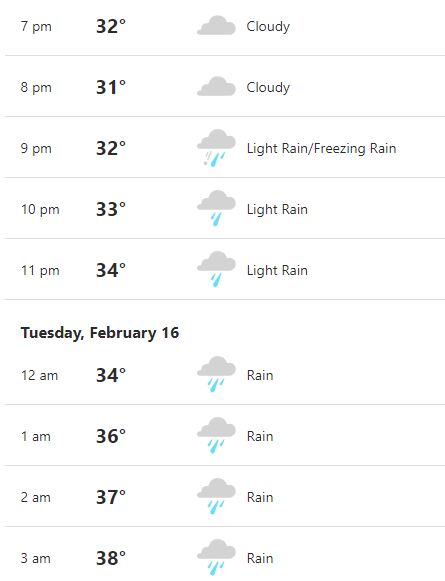
Tomorrow, Monday 2/15, snow and sleet during the day, light and spotty. Possibility of light freezing rain for a period. Do not expect more than a spotty thin glaze of ice, if even that.
Precipitation likely to become moderate to heavy after dark, likely changing over to all rain (the not-freezing kind) which should remove any previous ice and a significant portion of the current snow pack, too. Some local road ponding may occur where storm drains are not clear.
Tuesday through Tuesday night will see a hard freeze. Any standing water on the ground will become ice so be careful Wed morning. This does not mean that roads will be ice covered, only that there may be patches where puddles have frozen.
Later in the week right now looking like possible snow changing over to rain Thurs - Fri.
Tomorrow North and West of the area there is a much greater possibility of ice and you might hear warnings in the media that do not directly apply to MAPSO.

Winter Weather Advisory
URGENT - WINTER WEATHER MESSAGE
National Weather Service New York NY
332 PM EST Sun Feb 14 2021

CTZ007-009-010-NJZ006-104>108-NYZ071>075-176-178-150445-
/O.NEW.KOKX.WW.Y.0007.210215T1200Z-210216T1200Z/
Northern Middlesex-Southern Fairfield-Southern New Haven-Hudson-
Eastern Bergen-Western Essex-Eastern Essex-Western Union-
Eastern Union-Southern Westchester-New York (Manhattan)-Bronx-
Richmond (Staten Island)-Kings (Brooklyn)-Northern Queens-
Southern Queens-
332 PM EST Sun Feb 14 2021

...WINTER WEATHER ADVISORY IN EFFECT FROM 7 AM MONDAY TO 7 AM EST
TUESDAY...

* WHAT...Freezing rain expected. Total ice accumulations of
  around one tenth of an inch.

* WHERE...Portions of northeast New Jersey, southern Connecticut
  and southeast New York.

* WHEN...From 7 AM Monday to 7 AM EST Tuesday.

* IMPACTS...Difficult travel conditions are possible. The
  hazardous conditions could impact the morning and evening
  commutes.

* ADDITIONAL DETAILS...Pockets of light freezing rain or freezing
  drizzle will produce a light glaze at times on Monday. A
  steadier period of freezing rain can be expected Monday night
  before changing to rain.

PRECAUTIONARY/PREPAREDNESS ACTIONS...

Looks like freezing rain tomorrow. I still have flashbacks to 1994 Or 1996 I think it was. I was stuck on 78 for hours. A nightmare.

foo. another early morning dr. appt tomorrow. Hope it holds off for awhile.

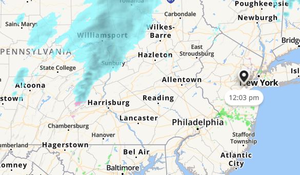
See that red area in Morristown? That is my house. We are on a nice hill with great views over the valleys and awesome sunrises and sunsets. That is the good part of it. Map is from NWS Mt Holly.

How's the path looking. Appears to be a ways out still. Freezing drizzle starting at 7pm.
Thursday forecasts are looking interesting, if I am reading them right (and that is an open question). Two lows are moving into our area, after cold air on Wednesday. If it starts to precip earlier than midnight Wed into Thursday it looks like all snow before eventually mixing to rain later on Thursday. If the precip holds off until warmer air arrives on Thursday then it will be a rain/snow mix with more rain than snow. It sounds like the rain/snow line will be hard to forecast on this one.

mfpark said:
Thursday forecasts are looking interesting, if I am reading them right (and that is an open question). Two lows are moving into our area, after cold air on Wednesday. If it starts to precip earlier than midnight Wed into Thursday it looks like all snow before eventually mixing to rain later on Thursday. If the precip holds off until warmer air arrives on Thursday then it will be a rain/snow mix with more rain than snow. It sounds like the rain/snow line will be hard to forecast on this one.
Yes, that's pretty accurate
I think we're dodging this ice storm. Looks like it's trending to only rain.
jamie said:
I think we're dodging this ice storm. Looks like it's trending to only rain.
I have tried to emphasize from the beginning that, even if we get freezing rain, this not an ice storm here in MAPSO. North and west is another thing entirely.
Monday Evening Update, 2/15
Very spotty light precipitation becomes steady around 10:00pm. Although this could be either rain or freezing rain, only a light glaze of ice is expected before the precipitation turns over to rain tonight (probably between midnight and 2:00am). Rain becomes heavy, and the heavier rain will be coupled with gradually rising temperatures, washing away any ice and a lot of the current snow pack. Total QPF (water that falls from the sky in any form) could easily reach 3/4" by the time it tapers off mid-morning tomorrow. Add to that the melted snow and there could be some road ponding and a bit of low-level flooding, so don't drive willy-nilly into puddles tomorrow morning if you don't know how deep they are.
Wednesday will be nice, although cold in the morning but a few degrees above freezing in the afternoon.
Right now Thursday looks like a classic early spring snow-into-sleet-into-rain gig. Keeping an eye on this one but the most likely scenario based on today's models is a messy Friday morning commute with sleet and rain possible but not looking like any ice in this one.
There is still a Winter Weather Advisory up for ice tonight so be careful if you go out.
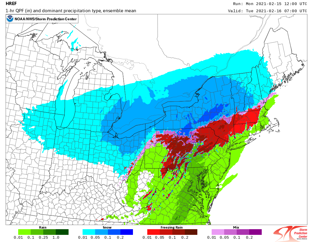
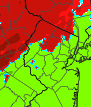
Image below shows how by the wee hours we expect the weather to be changed over to all rain. Green is rain, red is freezing rain and is by this point is north of MAPSO. The blue in upstate New York is, of course, snow. That is upstate New York, after all.
mfpark said:
See that red area in Morristown? That is my house. We are on a nice hill with great views over the valleys and awesome sunrises and sunsets. That is the good part of it. Map is from NWS Mt Holly.
You can clearly see on the SPC image how the models prog the freezing rain to linger in upper Morris county like you noticed on Mt. Holly's image

max_weisenfeld said:b
lue in upstate New York is, of course, snow. That is upstate New York, after all.
Uhh, yeah. That's more like central New York but it's okay. ;-) Living down here is like a vacation from the white stuff when you're used to the Tug Hill Plateau landing strip for lake-effect snow.
Much love, Max.
bikefixed said:
max_weisenfeld said:b
lue in upstate New York is, of course, snow. That is upstate New York, after all.
Uhh, yeah. That's more like central New York but it's okay. ;-) Living down here is like a vacation from the white stuff when you're used to the Tug Hill Plateau landing strip for lake-effect snow.
Much love, Max.
That heaviest blue stripe is right over my home town, so when I say upstate I think I know where I'm talking about.

I went to grad school in Syracuse for 2 years. That was a lot of snow. I drove to Buffalo in a massive blizzard because, well, it just always seemed like a blizzard during 6 months of the year.
I don't like the cold, so, unsurprisingly, Syracuse was not a good match for me.
Rain ending this morning, Tues 2/16.
Tomorrow, Wed, clear with seasonable Temps.
Thursday looking more and more like several inches of snow during the day and evening, with sleet and rain possible overnight. By Friday morning could have ground accumulation of a few inches of wet heavy snow. Snow and sleet could impact both commutes Thurs and also Friday morning. The rain/snow line passes very close to us so will have to wait until tomorrow for a more detailed forecast to come into focus.

I just saw a weather forecast (CBS News) for 4 -10 inches of snow on Thursday, February 18, 2021. Is this accurate as of now for our area and if so, is there any indication of about when the storm would start and its approximate duration?

Taking the short term view. If the rain, warm temps and partial sun reduce the snow and leave streets dry before overnight sub-freezing temps, I'll be happy. I'll deal with Thursday when it comes.
max_weisenfeld said:
I think Joan and I cross-posted
Yes. Thank you for answering my question before I could enter it.
drummerboy said:
Taking the long term view, I'll worry about Thursday now.
LOL!

This next storm looks strange to me. I don't know that I believe any of the big total snow maps that are being thrown around. I'm in the 3-6" camp for now.
WxNut2.0 said:
This next storm looks strange to me. I don't know that I believe any of the big total snow maps that are being thrown around. I'm in the 3-6" camp for now.
I'm with you on the low end. FFor one thing, the last few hours are not going to be anything like a 10:1 yield

Do we know yet when the snow might start on Thursday or are we too far out? I am apparently incompetent on all of the weather sites.
Rentals

Sponsored Business


Promote your business here - Businesses get highlighted throughout the site and you can add a deal.

Happy Valentine's Day Max and thank you for all the weather reporting year in and year out!