Winter Weather Advisory Monday 2/22 for 2" - 4" of !@#$%&* Snow


thanks. yeah, I will be. I was hoping to just hunker down for the day, but....

Fri 2/19 Morning Update
Winter Weather Advisory remains in effect all day for snow and sleet
Light snow, sleet, and freezing drizzle likely this morning tapering off early afternoon. Could see accumulations of an inch or more, and a glaze of ice so be careful on the roads.
Temps remain below freezing until this afternoon, and mostly at or slightly above freezing for the next few days. Next precipitation could be Monday.

drummerboy said:
looks like it be snowin' again.
(bleh. have to go to WF at 8 to get some clove oil. I have a dry socket. and it hurts.)
Does anyone know what the official snowfall was for yesterday?
...ESSEX COUNTY...
WEST ORANGE                  4.0 IN    0400 PM 02/18   PUBLIC
CEDAR GROVE                  3.8 IN    0415 PM 02/18   PUBLIC
NUTLEY                       3.5 IN    0130 PM 02/18   PUBLIC
NORTH CALDWELL               3.1 IN    0420 PM 02/18   TRAINED SPOTTER

At least there's a glimmer of hope for sunshine and slightly warmer temps the next couple of weeks.

I'm looking forward to spring in my gardens. Maybe this good hard freeze pattern with snow hanging around for so long will be healthy.
https://soilsmatter.wordpress.com/2017/02/15/why-is-it-good-to-have-the-ground-covered-by-snow/

I'm looking forward to string of a sunny days without snow. I'll accept the cold for a while.
Finally looking at the end of this cycle of snow and rain. Just one more to go!
Tomorrow, Monday, 2/22, expect snow mid morning to change over through rain/snow mix to all rain, ending by evening.
Do not expect more than an inch of accumulation.
Potential after that to go a *whole week* without precipitation!

Thanks Max! And thank you for updating the thread title for those of us looking for your latest forecast.


In reply to bikefixed article on the snow being good for the soil, I have a good report. One year, it snowed in March. I had a bare area in my yard with no grass. As a sort of experiment, I threw grass seed into the snow. This area of grass grew really well and better than the rest of the yard come springtime. I think snow also has some nitrogen in it.
bikefixed said:
I'm looking forward to spring in my gardens. Maybe this good hard freeze pattern with snow hanging around for so long will be healthy.
https://soilsmatter.wordpress.com/2017/02/15/why-is-it-good-to-have-the-ground-covered-by-snow/
my husband always calls these late snows "poor man's fertilizer" !

to max and wxnut
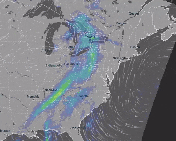
how do I interpret the below map? I'm assuming the blue-green front (it's a front, yes?) is moving towards us, with precipitation.
But the winds coming from the west seem to change direction when it hits the front, and then head north. Do the westerly winds still move the front eastward?
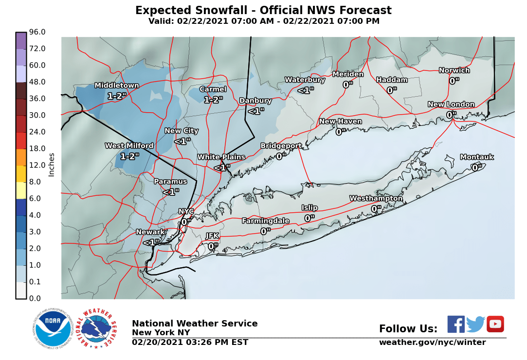
Mon 2/22. The NWS has issues a Winter Weather Advisory for today for a possible 2" - 4" of snow.
The last couple of model cycles have introduced a much heavier rate of precipitation into our area today. As a result, it is likely that the temperatures will not rise as much as expected, and that, what falls will more likely be snow than rain.
Snow, starting midmorning, likely heavy at times. May even hear a rumble of thundersnow midday. Snow ends around evening and may impact the evening commute.
Temps drop near freezing overnight but rise to near 40 tomorrow and likely higher Wednesday.
Winter Weather Advisory
URGENT - WINTER WEATHER MESSAGE
National Weather Service New York NY
305 AM EST Mon Feb 22 2021

CTZ005-NJZ002-004-103-105-NYZ067>070-222000-
/O.NEW.KOKX.WW.Y.0010.210222T1500Z-210222T2300Z/
Northern Fairfield-Western Passaic-Eastern Passaic-Western Bergen-
Western Essex-Orange-Putnam-Rockland-Northern Westchester-
305 AM EST Mon Feb 22 2021

...WINTER WEATHER ADVISORY IN EFFECT FROM 10 AM THIS MORNING TO
6 PM EST THIS EVENING...

* WHAT...Snow expected. Total snow accumulations of 2 to 4
  inches.

* WHERE...Portions of northeast New Jersey, southern Connecticut
  and southeast New York.

* WHEN...From 10 AM this morning to 6 PM EST this evening.

* IMPACTS...Plan on slippery road conditions. The hazardous
  conditions could impact the evening commute.

PRECAUTIONARY/PREPAREDNESS ACTIONS...

Slow down and use caution while traveling.

Check local Department of Transportation information services for
the latest road conditions.

&&

$
drummerboy said:
to max and wxnut
how do I interpret the below map? I'm assuming the blue-green front (it's a front, yes?) is moving towards us, with precipitation.
But the winds coming from the west seem to change direction when it hits the front, and then head north. Do the westerly winds still move the front eastward?
Weather in the middle latitudes of the northern hemisphere tends to move in a general west to east direction. The surface winds are a result of the weather, not a cause. So in the example you posted, the driving feature is a low pressure system centered over Michigan. The precipitation is out in front of the low, moving east. The southerly winds in front of the front were part of what I thought (along with a similar flow in the middle levels of the atmosphere) were going to keep the Temps warm today, but it looks like I was wrong about that. The surface winds behind the front are rotating clockwise around the low over Michagan.
max_weisenfeld said:
drummerboy said:
to max and wxnut
how do I interpret the below map? I'm assuming the blue-green front (it's a front, yes?) is moving towards us, with precipitation.
But the winds coming from the west seem to change direction when it hits the front, and then head north. Do the westerly winds still move the front eastward?
Weather in the middle latitudes of the northern hemisphere tends to move in a general west to east direction. The surface winds are a result of the weather, not a cause. So in the example you posted, the driving feature is a low pressure system centered over Michigan. The precipitation is out in front of the low, moving east. The southerly winds in front of the front were part of what I thought (along with a similar flow in the middle levels of the atmosphere) were going to keep the Temps warm today, but it looks like I was wrong about that. The surface winds behind the front are rotating counter clockwise around the low over Michagan.
ahh, ok. thanks much.

max_weisenfeld said:
I fixed a typo in my post. Winds in the northern hemisphere rotate clockwise, not counter clockwise.
You were right the first time: wind around a low rotates counter-clockwise in the northern hemisphere. Otherwise largely good with the description. Theres a relatively weak low (counter-clockwise flow) centered over the LP of Michigan with a large frontal zone (notice the elongated band of precip) extending to its south and east. Further east off the coast, there's a sprawling surface high (clockwise flow) centered offshore of the Carolinas.
One thing that's interesting here is that there's not likely much exceptionally cold air behind that low over Michigan. Typically you'll see an extensive area of wind out of the north that spills cold air behind the front. In this case the wind behind the front is from the west or even south west which should moderate temperatures.
WxNut2.0 said:
max_weisenfeld said:
I fixed a typo in my post. Winds in the northern hemisphere rotate clockwise, not counter clockwise.You were right the first time: wind around a low rotates counter-clockwise in the northern hemisphere. Otherwise largely good with the description. Theres a relatively weak low (counter-clockwise flow) centered over the LP of Michigan with a large frontal zone (notice the elongated band of precip) extending to its south and east. Further east off the coast, there's a sprawling surface high (clockwise flow) centered offshore of the Carolinas.
One thing that's interesting here is that there's not likely much exceptionally cold air behind that low over Michigan. Typically you'll see an extensive area of wind out of the north that spills cold air behind the front. In this case the wind behind the front is from the west or even south west which should moderate temperatures.
#weatherbeforecoffee is never a good idea....

From what I can see on the fencepost which was clear this morning, we've had a couple of inches.
I went out around noon; roads were covered but not bad. Came back before 1pm; roads were not good. If you must go out, make sure you turn on your lights and take it slow. Also, take your vehicle out of overdrive.

It's supposed to hit 36 degrees this afternoon. Is it going to turn to rain?
Seems to be raining lightly now in Maplewood. Looks like less than an inch of very heavy, very slushy stuff on the street, sidewalks, and driveway.

Featured Events
-
Stephen Whitty Presents - Hometown Movie Stars: The Celebrated Actors Of CHS
May 6, 2024 at 7:00pm
-
'Beethoven's Wrong Note: A Steampunk Opera'
May 12, 2024 at 2:00pm


looks like it be snowin' again.
(bleh. have to go to WF at 8 to get some clove oil. I have a dry socket. and it hurts.)
Does anyone know what the official snowfall was for yesterday?